An online project under the direction of the CAPE ANN MUSEUM
Catalogue Entry
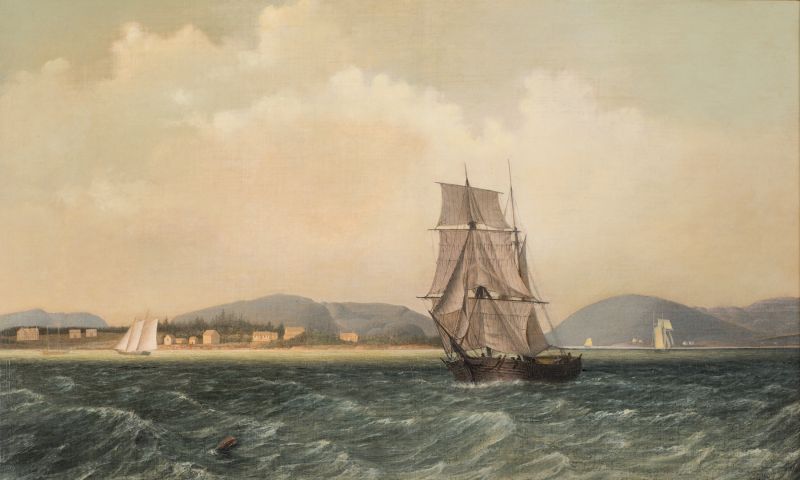
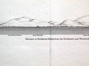
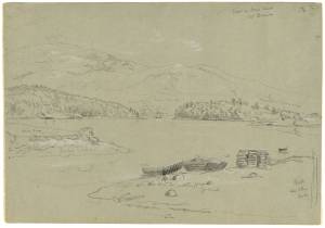
This painting follows closely Lane’s sketch titled Southwest Harbor, Mount Desert, 1852 (inv. 184) (probably given its title by Stevens, whose notes add that it was “taken from sloop ‘Superior’ at anchor”). The “Superior” was probably anchored near the southwest shore of the harbor, opposite Clarke’s Point, looking north-by-east toward Robinson’s Mountain (to the left of the half brig in the foreground). The brig’s sails obscure the entrance to Somes Sound. The mountain to the right is Brown’s Mountain on the east side of Somes Sound. The mountains to the left, on the west side of the sound, are Flying Mountain and Robinson’s Mountain. At far left is Beech Mountain with the hollow for Echo Lake to its right. Lane’s view of the Southwest Harbor settlement is limited to the southeast half of Clarke’s Point; the greater part of the community lies at the head of the harbor, well beyond the left margin of this image. The open water to the right of the brig is one of two channels around Greening’s Island leading to the entrance to Somes Sound. The houses in the distance are on Manchester Point, which marks the east side of the sound’s entrance.
The half brig in right-center foreground appears to be hove-to, but in the absence of a pilot vessel close by, or a pilot being conveyed in a small boat, there is little reason for this maneuver. More likely, the vessel is tacking in haste, due either to a sudden wind shift or to avoid shallows. Wind shifts are common on this coast, thanks to the hilly topography, which may explain why the schooner (left background) and topsail schooner (right background) have trimmed their sails to a different wind direction.
Lane’s treatment of the water indicates a breezy day for vessels in this region. Any sailor would appreciate the near-photographic treatment of the choppy waves and wind-blown spray. The light color of the distant water reflects a break in the dense cloud cover, while the sunlight reflected off the turbulent cloud bank adds to the unsettled state of the weather.
– Erik Ronnberg
- Subject Types
: - Vessel Types
: - Maine Buildings & Locales
: - New England Locales
: - Maine »
Historical Materials
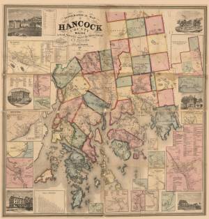
Mount Desert was in the Frenchman's Bay Customs District, and in 1850 the district ranked 4th, at 11.2%, among Maine's 13 customs districts, for its investment in the cod fisheries. The thick, old-growth forest provided ample opportunity for sawmills and the export of pine lumber and timber, as well as shipbuilding, which went hand-in-hand with fishing vessels for the cod fisheries.The coasters of the island found ample freight in the shipment of lumber from the sawmills of the Union River at Ellsworth. The rugged interior of the island limited settlements to the coastal fringe, creating a number of independent, isolated communities. Mount Desert's small fishing and farming communities, in the early 1850s, were set like small diamonds in an incredible crown of natural beauty. These small, isolated villages, clinging to a jagged coastline which stood resolute against the breaking sea, would have reminded artists like Lane of an America untouched by the progress of time. This was New England as it had once been, and there were few places in coastal New England where this claim could still be made.
Mount Desert, as it is colloquially known, has been known by many names throughout its history. The Etchemin called it Pem-etn-ic, "a range of mountains," as seen from the sea, "where the hills rise in a long saw-toothed range," Champlain called the island, notable for its granite mountains, of which one rises 1530 feet , "Isle des Monts Deserts," "barren mountains Island," and Sieur de la Mothe de Cadillac, who was granted a large tract at the head of Frenchman Bay in 1687, called Douaquet. Cadillac is one of a number of Frenchman whose presence in history is denoted by Frenchman's Bay.
At the beginning of recorded history Asticou was an Etchemin Sakom who lived seasonally on Mount Desert with his band. His larger homeland, Ketakamigwa, "the big land on the seacoast," was "an ecologically diverse coastal woodland environment, combining a saltwater archipelago with a 1000 mi.² freshwater hinterland broken by hills, swamps, lakes and ponds, and drained by a few major rivers in numerous smaller streams." The highly mobile Wabenaki families, ethnically identified as Etchemins, inhabited Penobscot Bay, making full use of the abundance of natural resources, including the building of a fish weir, K'chi-siti-mokan'gan, "The Great Fish Weir," between Little and Big Deer Isle, from which Eggemoggin Reach is derived), and shaping the natural environment to suit their needs.
Asticou, or members of his band, were on hand to greet Champlain in 1604, and he was at Manchester Point in 1613 when Father Baird and three Jesuit priests dropped anchor on their way to establish a Catholic mission on the Penobscot River. Asticou invited them to stay, the invitation was accepted, and the mission of St. Sauveur at Fernald Point began to be built. The work had barely begun when the mission was destroyed by Capt. Samuel Argall, an English privateer from Jamestown.
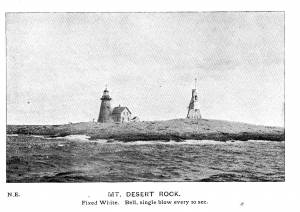
Champlain named Mount Desert but left its sentinel rock, 26 miles off shore, unidentified. The island was given the name of Mount Desert Dry Rock in the 18th century, and shortened somewhat after this. The island served as a navigational aid, not a hazard, for coastal seamen. The US government purchased this pile of rocks from the State of Maine in 1829, there surely must have been a few laughs over this transaction, and the government authorized $5000 to build a light station, which began operation in 1830.
– Mark Honey
References:
Conkling, Philip W, "Islands in Time," A Natural and Cultural History of the Islands of the Gulf of Maine, Island Institute, Rockland, and Downeast Books, Camden.
Eckstorm, Fannie Hardy, "Indian Place-Names of the Penobscot Valley and the Maine Coast," University of Maine Studies, 2nd Series, #55, November 1941, reprinted 1960 by the University of Maine Press. Frank G Speck's "Penobscot Man," University of Pennsylvania Press, 1940.
Duncan, Roger F, "Coastal Maine, A Maritime History," WW Norton & Company, New York, 1992.
Prins, Harald E L, and McBride, Bunny, "Asticou's Island Domain: Wabenaki Peoples at Mount Desert Island," 1500-2000, Acadia National Park, Ethnographic Overview and Assessment, Volume 1, repaired under cooperative agreement with The Abbe Museum, Bar Harbor, Maine, Northeast Regional Ethnography Program, National Park Service, Boston, Massachusetts, September, 2007.
Rowe, William Hutchinson, "The Maritime History of Maine," Harpswell Press, 1996.
Newsprint
Gloucester Daily Telegraph
Article by Joseph L. Stevens
"The beauties of this place [Maine] are well known and appreciated among artists. We heard of Bonfield and Williams who had reluctantly left but a short time before. Fishe had spent several weeks there. Champney and Kensett were then in another part of the island, and we have reason to believe that Church and some others were in the immediate vicinity–Lane who was with us, made good additions to his portfolio."
View related catalogue entries (12) »
Also filed under: Chronology » // Newspaper / Journal Articles » // Stevens, Joseph, Jr. »
Newspaper
Gloucester Telegraph p. 2, col. 3
Boston Public Library
Accession # G587
"PICTURES. – Two of Lane's finest paintings are on exhibition at the Marine Insurance Reading Room. One is a most spirited representation of a gale on the sea coast. Huge rollers come rumbling towards the rocky foreground where the spray dashes high and the receding wave is thrown up sharp and wedgelike by the great crested breaker under which it is speedily overwhelmed. In the middle distance a bald headland receives the sun's rays which slant through the mist from an opening in the heavy clouds. A close reefed ship leaps proudly over the waves and safely weathers the dangerous point beyond.
The companion-piece is a bay scene in which the setting sun throws a flood of golden light over the placid water. Vessels of different kinds, with sails in light and shadow, enliven the picture. A homely old sloop getting underweigh well sets off the most prominent object - a handsome ship under full canvass, slowly gliding over the ground-swell with a light breeze afloat, while there is hardly enough below to make a cat's paw.
These pictures were painted for the spring exhibition of the National Academy at New York, whither they will go unless stopped by some appreciative purchaser.
In Lane's studio are several gems of art. - Wind against Tide on Georges, a stirring pure marine, and Recollections of Mount Desert, an exquisite bit of landscape, evince a versatility of pencil which he is not generally known to possess.
The demand for a View of Gloucester worth having (as that poor caricature of Tidd's is not) has induced Lane to supply another, which is the third and largest of his series. It is taken from Rocky Neck, like its predecessor. Of course all the modern improvements visible from that point of view are represented with the artist's usual accuracy of drawing. To the first 300 subscribers the print will be offered at the low price of $2.25 per copy. The original painting from which it is lithographed, and several other of his pictures, will be distributed by lot among those who choose to take their copies at $2.75 – a price which the print alone will command before the entire edition is exhausted."
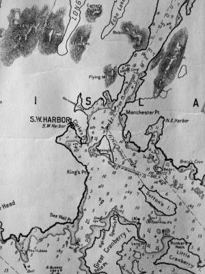
Chart G
Charles G. Hutchinson, Publisher
Private Collection
George W. Eldridge was a Boston-based publisher of charts, pilot books, and tide tables for yachtsmen cruising in the New York–New England region. Detail of the Mount Desert portion of a much larger chart.
Also filed under: Maps » // Northeast Harbor » // Somes Sound »
Chart
U.S. Coast Survey
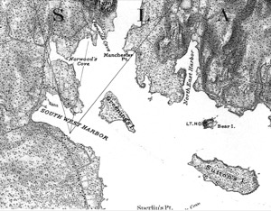
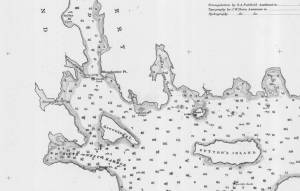
Chart with key showing the route of an excursion on the sloop "Superior" out of Castine made by William H. Witherle, Lane, Stevens and friends during which Lane made several sketches of Mt. Desert scenery. The trip was chronicled by Witherle in his diary of 1852.
View related catalogue entries (6) »
Also filed under: "Superior" (Sloop) » // Castine » // Penobscot Bay » // Southwest Harbor » // Witherle, William Howe »
Illustration
"U.S. Coast Pilot, Atlantic Coast, Parts I–II." First edition. Published by Washington GPO, 1891
Folded plate between pp. 62 and 63
Also filed under: Bear Island » // Maps » // Northeast Harbor, Maine – Bear Island Lighthouse » // Southwest Harbor »
Photograph
From The Illustrated Coast Pilot with sailing directions. The Coast of New England from New York to Eastport, Maine including Bays and Harbors, published by N. L. Stebbins, Boston, Mass.
Also filed under: Mount Desert, Maine – Mount Desert Rock Light »
Wilson Museum, Castine, Maine.
Library of Congress Catalog Number 2011588006
1860 map, including census of towns.
Also filed under: Castine » // Maps » // Penobscot Bay »
Personal diary
Wilson Museum, Castine, Maine (A00060-1a-1h)
Description of an excursion taken by Joseph Stevens, Jr., Lane, Witherle, Samuel Adams, Jr., and George Tilden around the islands of Maine near Mt. Desert. The group hired the Sloop "Superior" which was owned by Pilot Getchell. In his diary, Witherle mentions multiple times that "Lane took a sketch" especially when the water was calm. Lane often stayed on board the boat, while the others went ashore.
Excerpts of the diary include:
August 16: "Lane has a knack for frying fish."
August 17: "leaving Lane to take a sketch, we took a climb."
August 19: "went to ascend one of the highest mountains. 3/4 the way up we had to wait – once in a while for Lane who with his crutches could not keep up with us – but got along faster than we thought possible . . .Lane got up about an hour after the rest of us."
The entire text is transcribed in an account published by the Wilson Museum.
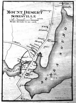
Mount Desert "displays several U-shaped valleys, almost perfectly parallel and trending a bit east of south; Somes Sound, nearly dividing the island in two, is of particular interest because it is a fjord, a valley cut much deeper than sea level by a glacier that extended an unknown distance out to sea. The Valley was later filled by the sea when the meltwater from the wasting ice raised sea level to its present elevation."
Abraham Somes is alleged to have made seasonal fishing trips to Somes Sound as early as 1755, though he did not begin the process of settlement until 1761. He removed his family through the Head of the Sound in 1762 and erected a sawmill. The Sound and the village bear his name. Through extended family kinships, the Somes family would be connected to the sawmill families of Flye of Union River and the Herrick's of Mount Desert, Sedgwick, and Penobscot.
– Mark Honey
References:
Honey, Mark E, "King Pine, Queen Spruce, Jack Tar," An Intimate History of Lumbering on the Union River, Volumes 1-5.
Kendall, David L, "Glaciers & Granite," A Guide to Maine's Landscape and Geology, Downeast Books, Camden, 1987
Chart G
Charles G. Hutchinson, Publisher
Private Collection
George W. Eldridge was a Boston-based publisher of charts, pilot books, and tide tables for yachtsmen cruising in the New York–New England region. Detail of the Mount Desert portion of a much larger chart.
Also filed under: Maps » // Mount Desert Island & Rock » // Northeast Harbor »
19 x 28 in.
Survey of the Coast of the United States, Washington, D.C.
Also filed under: Bear Island » // Maps » // Northeast Harbor, Maine – Bear Island Lighthouse »
Personal diary
Wilson Museum, Castine, Maine (A00060-1a-1h)
Description of an excursion taken by Joseph Stevens, Jr., Lane, Witherle, Samuel Adams, Jr., and George Tilden around the islands of Maine near Mt. Desert. The group hired the Sloop "Superior" which was owned by Pilot Getchell. In his diary, Witherle mentions multiple times that "Lane took a sketch" especially when the water was calm. Lane often stayed on board the boat, while the others went ashore.
Excerpts of the diary include:
August 16: "Lane has a knack for frying fish."
August 17: "leaving Lane to take a sketch, we took a climb."
August 19: "went to ascend one of the highest mountains. 3/4 the way up we had to wait – once in a while for Lane who with his crutches could not keep up with us – but got along faster than we thought possible . . .Lane got up about an hour after the rest of us."
The entire text is transcribed in an account published by the Wilson Museum.
View related catalogue entries (6) »
Also filed under: "Superior" (Sloop) » // Adams, Samuel, Jr. » // Biographical information » // Blue Hill » // Castine » // Chronology » // Diaries / Ledgers / Etc. » // Mount Desert Island & Rock » // Stevens, Joseph, Jr. » // Tilden, George » // Witherle, William Howe »
Southwest Harbor and Northeast Harbor flank Somes Sound of Mount Desert. The harbor is shared by two small villages, Manset, to the south, and Southwest Harbor and Clark Point to the north.The community often sent fishing vessels to the Labrador fleet. The swelling tide of artists, sightseers, philosophers, and pilgrims in the 1830s, '40s, and '50s would inspire such entrepreneurs as Deacon Henry H. Clark of Southwest Harbor, a shipwright, to build hotels to accommodate the travelers. This was a growth industry would sustain the prosperity of the island communities and their small farms in the years after the Civil War.
Southwest Harbor, which included Tremont until 1848, sent six schooners averaging 58 tons with the Labrador fleet in 1839. The smallest of these vessels was the 35 ton "Four Sisters" which could not have exceeded 50 feet. The Labrador fishery was ideal for such a small craft, for it allowed vessels to anchor in safe harbors, unbending their sails, and setting their men adrift in small boats near the shore. This practice would continue into the 1860s. These small vessels were ideal for men with limited capital who could easily afford to build and maintain these small vessels. More often than not, the crew would consist of a father and his sons, or all of the able-bodied men living in a small island community.
The British raided what is now Southwest Harbor in 1775 and attacked the home of John Manchester. The British killed or stole the livestock, took all of the winter provisions, and returned to the westward on board the "Falmouth Packet," but not before they told Mrs. Manchester that she could starve for all they cared. John Bunker, Manchester's brother-in-law, paddled his canoe westward in pursuit of the marauding British. He found them on the Sheepscot River at Wiscasset, and the "Falmouth Packet" at anchor with her crew on shore. He cut the lines in the dark of night, let the schooner drift with the tide, and then made sail, heading back to Mount Desert. The supplies were badly needed, as Downeast Maine was caught in the grip of a British embargo and families were starving. The supplies would carry the settlers through the winter. The British would come calling again on August 8, 1814, aboard the sloop of war "Tenados," and lost seven soldiers in a skirmish off Clark's Point. Capt. Benjamin Spurling of Cranberry Isle, whose grandson would be awarded the Medal of Honor after the Civil War, was in the thick of fighting with a ragtag band of fishermen who could only loosely be called a militia. Capt. Spurling would command a privateer during the war.
– Mark Honey
References:
Duncan, Roger F, "Coastal Maine, A Maritime History," WW Norton & Company, New York, 1992
O'Leary, Wayne M, "Maine Sea Fisheries," The Rise and Fall of a Native Industry, 1830-1890, Northeastern University Press, Boston, 1996.
Chart
U.S. Coast Survey
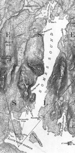
Chart with key showing the route of an excursion on the sloop "Superior" out of Castine made by William H. Witherle, Lane, Stevens and friends during which Lane made several sketches of Mt. Desert scenery. The trip was chronicled by Witherle in his diary of 1852.
View related catalogue entries (6) »
Also filed under: "Superior" (Sloop) » // Castine » // Mount Desert Island & Rock » // Penobscot Bay » // Witherle, William Howe »
Illustration
"U.S. Coast Pilot, Atlantic Coast, Parts I–II." First edition. Published by Washington GPO, 1891
Folded plate between pp. 62 and 63
Also filed under: Bear Island » // Maps » // Mount Desert Island & Rock » // Northeast Harbor, Maine – Bear Island Lighthouse »
"Superior" and its Pilot Getchell, were hired by Joseph Stevens, Jr., Lane, and three others (Adams, Witherle, and Tilden) to take them on a week-long excursion in August of 1852 in Penobscot Bay.
Chart
U.S. Coast Survey
Chart with key showing the route of an excursion on the sloop "Superior" out of Castine made by William H. Witherle, Lane, Stevens and friends during which Lane made several sketches of Mt. Desert scenery. The trip was chronicled by Witherle in his diary of 1852.
View related catalogue entries (6) »
Also filed under: Castine » // Mount Desert Island & Rock » // Penobscot Bay » // Southwest Harbor » // Witherle, William Howe »
Personal diary
Wilson Museum, Castine, Maine (A00060-1a-1h)
Description of an excursion taken by Joseph Stevens, Jr., Lane, Witherle, Samuel Adams, Jr., and George Tilden around the islands of Maine near Mt. Desert. The group hired the Sloop "Superior" which was owned by Pilot Getchell. In his diary, Witherle mentions multiple times that "Lane took a sketch" especially when the water was calm. Lane often stayed on board the boat, while the others went ashore.
Excerpts of the diary include:
August 16: "Lane has a knack for frying fish."
August 17: "leaving Lane to take a sketch, we took a climb."
August 19: "went to ascend one of the highest mountains. 3/4 the way up we had to wait – once in a while for Lane who with his crutches could not keep up with us – but got along faster than we thought possible . . .Lane got up about an hour after the rest of us."
The entire text is transcribed in an account published by the Wilson Museum.
View related catalogue entries (6) »
Also filed under: Adams, Samuel, Jr. » // Biographical information » // Blue Hill » // Castine » // Chronology » // Diaries / Ledgers / Etc. » // Mount Desert Island & Rock » // Somes Sound » // Stevens, Joseph, Jr. » // Tilden, George » // Witherle, William Howe »
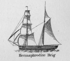
Hermaphrodite brigs—more commonly called half-brigs by American seamen and merchants—were square-rigged only on the fore mast, the main mast being rigged with a spanker and a gaff-topsail. Staysails were often set between the fore and main masts, there being no gaff-rigged sail on the fore mast. (1)
The half-brig was the most common brig type used in the coasting trade and appears often in Lane’s coastal and harbor scenes. The type was further identified by the cargo it carried, if it was conspicuously limited to a specialized trade. Lumber brigs (see Shipping in Down East Waters, 1854 (inv. 212) and View of Southwest Harbor, Maine: Entrance to Somes Sound, 1852 (inv. 260)) and hay brigs (see Lighthouse at Camden, Maine, 1851 (inv. 320)) were recognizable by their conspicuous deck loads. Whaling brigs were easily distinguished by their whaleboats carried on side davits (see ). (2)
– Erik Ronnberg
References:
1. M.H. Parry, et al., Aaak to Zumbra: A Dictionary of the World's Watercraft Newport News, VA: The Mariners’ Museum, 2000), 268, 274; and A Naval Encyclopaedia (L.R. Hamersly & Co., 1884. Reprint: Detroit, MI: Gale Research Company, 1971), 93, under "Brig-schooner."
2. W.H. Bunting, An Eye for the Coast (Gardiner, ME: Tilbury House: 1998), 52–54, 68–69; and W.H. Bunting, A Day's Work, part 1 (Gardiner, ME: Tilbury House: 1997), 52.

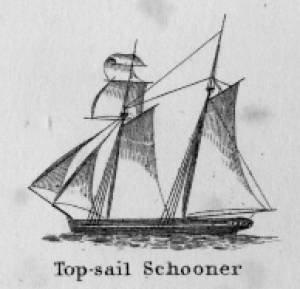
Schooners in Lane’s time were, with few exceptions, two-masted vessels carrying a fore-and-aft rig having one or two jibs, a fore staysail, gaff-rigged fore- and main sails, and often fore- and main topsails. One variant was the topsail schooner, which set a square topsail on the fore topmast. The hulls of both types were basically similar, their rigs having been chosen for sailing close to the wind. This was an advantage in the coastal trade, where entering confined ports required sailing into the wind and frequent tacking. The square topsail proved useful on longer coastwise voyages, the topsail providing a steadier motion in offshore swells, reducing wear and tear on canvas from the slatting of the fore-and-aft sails. (1)
Schooners of the types portrayed by Lane varied in size from 70 to 100 feet on deck. Their weight was never determined, and the term “tonnage” was a figure derived from a formula which assigned an approximation of hull volume for purposes of imposing duties (port taxes) on cargoes and other official levies. (2)
Crews of smaller schooners numbered three or four men. Larger schooners might carry four to six if a lengthy voyage was planned. The relative simplicity of the rig made sail handling much easier than on a square-rigged vessel. Schooner captains often owned shares in their vessels, but most schooners were majority-owned by land-based firms or by individuals who had the time and business connections to manage the tasks of acquiring and distributing the goods to be carried. (3)
Many schooners were informally “classified” by the nature of their work or the cargoes they carried, the terminology coined by their owners, agents, and crews—even sometimes by casual bystanders. In Lane’s lifetime, the following terms were commonly used for the schooner types he portrayed:
Coasting schooners: This is the most general term, applied to any merchant schooner carrying cargo from one coastal port to another along the United States coast (see Bar Island and Mt. Desert Mountains from Somes Settlement, 1850 (inv. 401), right foreground). (4)
Packet schooners: Like packet sloops, these vessels carried passengers and various higher-value goods to and from specific ports on regular schedules. They were generally better-maintained and finished than schooners carrying bulk cargoes (see The Old Fort and Ten Pound Island, Gloucester, 1850s (inv. 30), center; and Gloucester Inner Harbor, 1850 (inv. 240), stern view). (5)
Lumber schooners: Built for the most common specialized trade of Lane’s time, they were fitted with bow ports for loading lumber in their holds (see View of Southwest Harbor, Maine: Entrance to Somes Sound, 1852 (inv. 260)) and carried large deck loads as well (Stage Rocks and the Western Shore of Gloucester Outer Harbor, 1857 (inv. 8), right). Lumber schooners intended for long coastal trips were often rigged with square topsails on their fore masts (see Becalmed Off Halfway Rock, 1860 (inv. 344), left; ; and Lumber Schooner in a Gale, 1863 (inv. 552)). (6)
Schooners in other specialized trades. Some coasting schooners built for carrying varied cargoes would be used for, or converted to, special trades. This was true in the stone trade where stone schooners (like stone sloops) would be adapted for carrying stone from quarries to a coastal destination. A Lane depiction of a stone schooner is yet to be found. Marsh hay was a priority cargo for gundalows operating around salt marshes, and it is likely that some coasting schooners made a specialty of transporting this necessity for horses to urban ports which relied heavily on horses for transportation needs. Lane depicted at least two examples of hay schooners (see Gloucester Harbor, 1850s (inv. 391), left; and Coasting Schooner off Boon Island, c.1850 (inv. 564)), their decks neatly piled high with bales of hay, well secured with rope and tarpaulins.
– Erik Ronnberg
References:
1. Howard I. Chapelle, The History of American Sailing Ships (New York: W.W. Norton & Co., 1935), 258. While three-masted schooners were in use in Lane’s time, none have appeared in his surviving work; and Charles S. Morgan, “New England Coasting Schooners”, The American Neptune 23, no. 1 (DATE): 5–9, from an article which deals mostly with later and larger schooner types.
2. John Lyman, “Register Tonnage and its Measurement”, The American Neptune V, nos. 3–4 (DATE). American tonnage laws in force in Lane’s lifetime are discussed in no. 3, pp. 226–27 and no. 4, p. 322.
3. Ship Registers of the District of Gloucester, Massachusetts, 1789–1875 (Salem, MA: The Essex Institute, 1944). Vessels whose shipping or fishing voyages included visits to foreign ports were required to register with the Federal Customs agent at their home port. While the vessel’s trade or work was unrecorded, their owners and master were listed, in addition to registry dimensions and place where built. Records kept by the National Archives can be consulted for information on specific voyages and ports visited.
4. Howard I. Chapelle, The National Watercraft Collection (Washington, DC: Smithsonian Institution, 1960), 40, 42–43.
5. Ibid., 42–43, 73.
6. Ibid., 74–76.

In R. H. Dana, The Seaman's Friend, 13th ed. (Thomas Groom & Co. Publisher, 1873)
A topsail schooner has no tops at her foremast, and is fore-and-aft rigged at her mainmast. She differs from an hermaphrodite brig in that she is not properly square-rigged at her foremast, having no top, and carrying a fore-and-aft foresail instead of a square foresail and a spencer.

Detail views: marine railway and hauling cradle for vessel Wood rails, metal rollers, chain; wood cradle. Scale: ½" = 1' (1:24) Original diorama components made, 1892; replacements made, 1993. Cape Ann Museum, from Gloucester Chamber of Commerce, 1925 (2014.071)
A schooner is shown hauled out on a cradle which travels over racks of rollers on a wood and metal track.
Also filed under: Burnham Brothers Marine Railway » // Marine Railways »

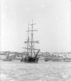
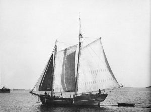
c. 1900 Glass plate negative Collection of Erik Ronnberg
Also filed under: Lobstering »
"The Maine Register for the Year 1855, embracing State and County Officers, and an abstract of the law and resolves; together with a complete business directory of the state, and a variety of useful information."
Details about Maine's lumber trade in 1855, see pp. 250–52
Also filed under: Castine » // Lumber Industry »
