An online project under the direction of the CAPE ANN MUSEUM
Catalogue Entry
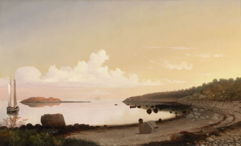
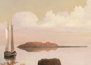
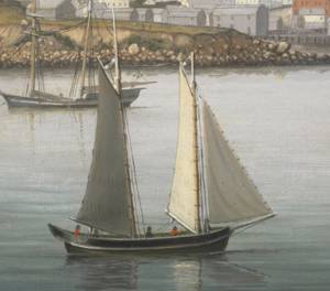
This painting is a masterpiece of Lane’s late work. The pellucid calm of the cove, the otherworldly glow of early twilight, the empty stage set of the beach spotted by the dark rocks of low tide, Norman’s Woe glowing in the distance—all epitomize the direction of Lane’s late work and the transcendent luminism for which he is most famous. Perhaps no other painting by Lane better embodies the transcendentalist’s vision of the presence of God and of man merging with a pristine Nature.
Though we have no direct evidence of Lane’s association with transcendentalist thought, he was certainly exposed to it through multiple lectures in Gloucester by Emerson and Thoreau. It is hard not to associate The Western Shore with Norman's Woe with the oft-quoted line from Ralph Waldo Emerson’s "Nature," “I become a transparent eyeball; I am nothing; I see all; the currents of the Universal Being circulate through me...” Lane’s lifelong fascination with the detail and anecdote of ships and harbors has been distilled into this pure expression of light and place, truly a masterpiece of the “poetry of emptiness,” a term often applied by scholars to Lane’s late work.
The painting is taken from a drawing, Norman's Woe, 1861 (inv. 114), on which it is noted that two paintings were made, one for Florence Foster and one for Benjamin H. Smith. Florence Foster was a good friend of Isabel Lane, who donated this picture to the Cape Ann Museum, suggesting that perhaps this was the version made for her.
The drawing is more fully developed and shaded than many of Lane’s sketches and is carefully gridded into squares for transfer onto canvas. Note the more prominent foliage in the left foreground of the drawing that is de-emphasized in this version of the painting, though more accurately reproduced in the other, Norman's Woe, Gloucester Harbor, 1862 (inv. 1). It may have been that Lane did that version first in a larger and more horizontal format, and then removed some of the detail and compressed the scene in this second version.
The composition takes the eye in an arc around the cove and out to the small island called Norman’s Woe, which glows in the distance. The foliage in the center foreground of the beach—shown in the drawing—has been removed, allowing the eye to proceed directly into the glassy calm of the cove and out to the sky and the cloud-form building in the distance. The far-off ship gives scale and distance to the scene while the pinky, with its sails set but nearly adrift, provides a boundary to the left edge of the composition.
The seaweed-covered rocks are an impossibly rich dark brown, in startling contrast to the brilliant sky that is reflected in the water of the cove. Note the colors in the sky, which transition from a purple in the upper left through a series of almost metallic, coppery yellows to the right. Seen at close hand, the coloration is almost surreal. It is not what one expects in a twilight sky and water, yet when one steps back, the colors integrate into a pervasive evening glow that is much more than the sum of its parts.
– Sam Holdsworth
- Subject Types
: - Landscape Types
: - Beach »
- Seasons / Weather
: - Vessel Types
: - Cape Ann Locales
: - Activities of People
: - Objects
:
Historical Materials
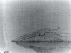
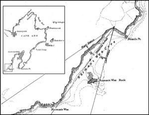
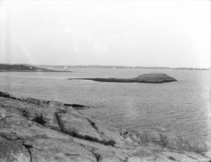
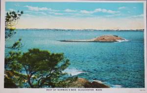
Norman’s Woe is a large rock sitting a few hundred feet off the western shore of Gloucester harbor. It lies between Gloucester and Magnolia and is just outside the confines of the harbor, if Eastern Point is used as the defining southern extent of the protected water. It can be reached from the shore at low tide over the rocks and is an island at high tide.
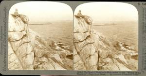
Tradition has it that a man named Norman was shipwrecked and lost there, but there is no historical record to substantiate it. Henry Wadsworth Longfellow memorialized it in his famous poem "The Wreck of the Hesperus" in 1840 though he never laid eyes on the rock until many years after he wrecked the Hesperus on it. His inspiration may have come from the wreck of the ship "Favorite" from Wiscasset, Maine on Norman’s Woe during the great blizzard of 1839. All hands were lost, one of whom was a woman who was found dead still tied to the mast which had floated ashore.
Because it lies outside the protection of the easterly arm of Eastern Point, Norman’s Woe and the surrounding rocky coast take the brunt of huge waves rolling in from the open ocean to the east, particularly after a storm. The high hills behind that western shore act as a wind block while tide and waves push a craft shoreward making Norman’s Woe the site of numerous shipwrecks and much loss of life through the years.
Lane did a drawing and some number of paintings of the site. He drew the rock from the shore looking to the south. Instead of the violent seas for which that shore is known he depicted it in a glassy calm. One of his landmark late paintings The Western Shore with Norman's Woe, 1862 (inv. 18) shows a boat drifting idly in the still late afternoon light in the cove just to the north of the rock of Norman’s Woe.
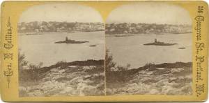
c.1860 Stereograph card Cape Ann Museum Library & Archive
Stereo View: "Geography – Norman's Woe is a headland on the mainland of Massachusetts just south of Gloucester Harbor, which is directly before us here. That very small island, to the left of the cliff, is called Norman's Woe Rock. Both places are so named because of the shipwreck of some member of the Norman family,who were among the early settlers in this locality.
Geology – The irregular jointing shows very clearly along the face of this cliff, where the action of the wind and weathering have cleared away the loose particles between the joints. The reason these rocks have withstood the destructive action of the erosion and weathering is because they are formed cheifly of felspar; in fact, this is a dike of that material.
Literature - Longfellow's poem, "The Wreck of the Hesperus," has immortalized the traditions that centre about these shores. The pounding of the waves uon this rock-bound promontory, and the dismal howling of the wind at this point, furnished him with the inspiration needed for his most favored masterpiece.
People and Homes - Seated upon our left is a very typical New England gentlemen, a real "down east Yankee." He exhibits all the qualities that made his ancestors so staunch in their determination to defend their adopted land."
Also filed under: Historic Photographs »

44 x 34 in.
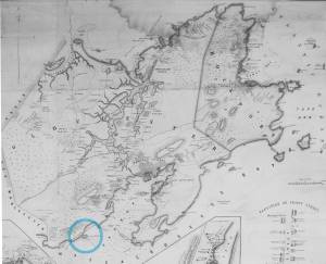
Henry Francis Walling, Map of the Towns of Gloucester and Rockport, Essex Co. Massachusetts. Philadelphia, A. Kollner, 1851
Cape Ann Museum Library & Archive
"Map of the Towns of Gloucester and Rockport, Massachusetts. H.F. Walling, Civil Engineer. John Hanson, Publisher. 1851. Population of Gloucester in 1850: 7,805. Population of Rockport in 1850: 3,213."
Also filed under: Annisquam River » // Brookbank » // Dolliver's Neck » // Fresh Water Cove » // Gloucester Harbor, Outer » // Maps » // Stage Rocks / Stage Fort / Stage Head » // Steepbank » // West Gloucester – Little River » // Western Shore »

Engraving of 1819 survey taken from American Coast Pilot 14th edition
9 1/2 x 8 in.
Cape Ann Museum Library & Archive
D32 FF5
Also filed under: Dolliver's Neck » // Eastern Point » // Maps » // Ten Pound Island »

Newspaper
Gloucester Telegraph
In this article, a moonlight view of the harbor of Cape Ann by Lane is described in detail by a viewer and his skill in depicting the Cape Ann coastline is praised. Lane's associates, Salmon and Birch, are mentioned, but as comparisons to Lane. "Those who visited his room, were highly pleased with the skill he manifested in portraying the beauties of our coast."
Also filed under: Newspaper / Journal Articles » // Salmon, Robert » // Studio Descriptions »
Newspaper
"Mr. Lane has just completed a third picture of the Western Shore of Gloucester Harbor, including the distance from 'Norman's Woe Rock' to 'Half Moon Beach.' It was painted for Mr. William E. Coffin of Boston, and will be on exhibition at the artist's rooms for only a few days; we advise all our readers who admire works of art, and would see one of the best pictures Mr. Lane has ever executed..."
"...solitary pine, so many years a familiar object and landmark to the fisherman."
Newspaper clipping
Cape Ann Advertiser
Cape Ann Museum Library & Archive
"F.H. Lane, Esq., has recently finished a splendid painting of Norman's Woe, and scenery in the vicinity. It is a sunset scene, and gorgeous to the extreme."
Also filed under: Newspaper / Journal Articles »
A Narrative poem based on the Blizzard of 1839 off Norman's Woe of Gloucester, in which many ships sank and many lives lost, including that of a woman whose body washed up on shore, still tied to a mast. There was also a real vessel "Hesperus" which wrecked off of Boston.
The Wreck of the Hesperus
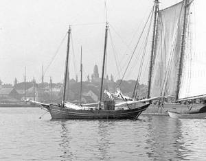
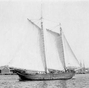
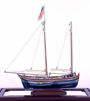
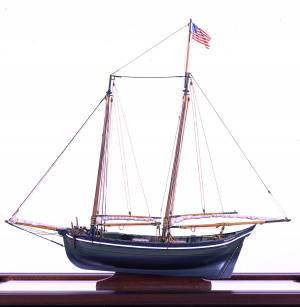
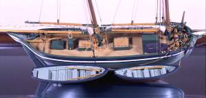
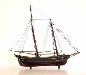
The colonial American shallop is the ancestor of many regional types of New England fishing craft found in Lane's paintings and drawings, including "New England Boats" (known as "boats" and discussed elsewhere), and later descendents, such as "Chebacco Boats," "Dogbodies," and "Pinkies."
These boats were very common work boat types on Cape Ann throughout the 1800s. They were primarily used for inshore coastal fishing, which included lobstering, gill-netting, fish-trapping, hand-lining, and the like. They were usually sailed by one or two men, sometimes with a boy, and could be rowed as well as sailed. An ordinary catch would include rock cod, flounder, fluke, dabs, or other small flat fish. The catch would be eaten fresh, or salted and stored for later consumption, or used as bait fish. Gill-netting would catch herring and alewives when spawning. Wooden lobster traps were marked with buoys much as they are today, and hauled over the low sides of the boat, emptied of lobsters and any by-catch, re-baited and thrown back.
CHEBACCO BOATS AND PINKIES
In the Chebacco Parish of the Ipswich Colony, a larger version of the colonial shallop evolved to a heavily built two-masted boat with either a sharp or square stern. This development included partial decking at bow and stern, the former as a cuddy which was fitted with crude bunks and a brick fireplace for cooking. Further development provided midship decking over a fish hold with standing rooms fore and aft for fishing. At this stage, low bulwarks replaced simple rails and in the double-enders were extended aft beyond the rudderhead to form a “pinched,” or “pink“ stern. Some time in the second half of the eighteenth century, boats with these characteristics became known as Chebacco Boats. The squarestern versions were called Dogbodies, for reasons now forgotten. (1)
Chebacco Boats became the vessels of choice for Cape Ann fishermen working coastal grounds for cod, mackerel, herring, and groundfish with hook and line or with nets. This did not prevent them from venturing further, particularly in pursuit of migrating schools of mackerel. The “Bashalore,” a corruption of the Bay of Chaleur in the Gulf of St. Lawrence, was a favorite destination for Cape Ann Fishermen who fished for mackerel in that region. (2)
Lane undoubtedly saw Chebacco Boats in the years prior to his move to Boston, but if he made drawings or paintings of them in that period, none have come to light. A small lithograph, titled “View of the Old Fort and Harbor 1837,” is attributed to him, but the vessels and wharf buildings are too crudely drawn to warrant this undocumented claim. (3) Lane did see and render accurately the Chebacco Boat’s successor the Pinky—which was larger and had a schooner rig (two masts, main sail, fore sail, jib, and main topmast staysail).
Schooners with pinksterns were recorded early in the 18th century later that there were models and graphic representations of hull form and rig (Ref. 4). By then, the pinky was very similar in hull form to Chebacco Boats, and some Chebacco Boats were converted to pinkies by giving them schooner rigs. A pinky in Lane’s The Old Fort and Ten Pound Island, Gloucester, 1850s (inv. 30) (misdated 1850s, more likely mid-1840s) is quite possibly an example of such a conversion.
Lane’s depictions of pinkies in Massachusetts waters are numerous and sometimes very informative. Examples in his views of Gloucester Harbor portray them at various angles, from broadside (see Gloucester Harbor from Rocky Neck, 1844 (inv. 14), The Old Fort and Ten Pound Island, Gloucester, 1850s (inv. 30), and View of the Town of Gloucester, Mass., 1836 (inv. 86)) to stern (see The Western Shore with Norman's Woe, 1862 (inv. 18), The Old Fort and Ten Pound Island, Gloucester, 1850s (inv. 30), and Gloucester Harbor, 1850s (inv. 391)), but few, if any, bow views. His portrayals of pinkies in Boston Harbor and vicinity are more in the foreground and more generous in detail. The earliest of these, from 1845, shows a pinky getting underway in a hurry as the yacht "Northern Light" bears down on her in The Yacht "Northern Light" in Boston Harbor, 1845 (inv. 268). A late harbor view (id ) offers a rare bow view.
Like the Chebacco Boat, the pinky was primarily a fishing vessel, doing much the same kind of fishing in coastal waters, but large enough to venture further offshore to work on the banks in the Gulf of Maine in pursuit of the cod. By the 1820s, pinkies reached their largest size: 50 to 60 feet on deck. Beyond that size called for a different deck arrangement and higher rails, so men could stand on deck and fish from the rails – an arrangement offered by the banks fishing schooner. (5)
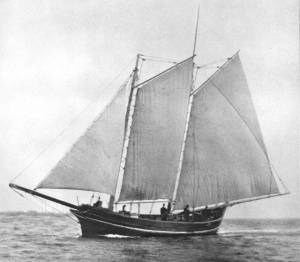
What is perhaps Lane’s most detailed and narrative view of a pinky appears in Becalmed Off Halfway Rock, 1860 (inv. 344) and dominates the right foreground. Fitted-out for mackerel gillnetting, she has a dory and a wherry in tow, the latter with the net in the stern. The crew is relaxed, enjoying the evening calm as the vessel heads for port. The barrels on deck are filled with freshly caught mackerel, which will be sold as such when landed, most likely at Gloucester. This pinky was probably fishing on Stellwagen Bank or Cape Cod Bay, which were good fishing grounds for mackerel, and close enough to Gloucester to make trips in smaller vessels worthwhile. To judge from his paintings, Lane found only a few pinkies in the parts of the Maine Coast he explored. Only one drawing (Southwest Harbor, Mount Desert, 1852 (inv. 184)) and two widely published paintings (Entrance of Somes Sound, Mount Desert, Maine, 1855 (inv. 347) and Bar Island and Mt. Desert Mountains from Somes Settlement, 1850 (inv. 401)) illustrate this type, and then at a distance. What is apparent is that pinkies in southern Maine did not differ markedly from those on the Massachusetts coast. Had Lane ventured further Down East, he might have found modifications to the type that reflected Canadian influences. (6)
– Erik Ronnberg
References:
1. William A. Baker, Sloops & Shallops (Barre, MA: Barre Publishing Co., 1966), 82–91; and Howard I. Chapelle, The American Fishing Schooners, 1825–1935 (New York: W.W. Norton & Co., 1973), 25–27.
2. G. Brown Goode, The Fisheries and Fishery Industries of the United States, Section V, Vol. I (Washington, DC: Government Printing Office, 1884–87), 275, 287, 298–300, 419–21, 425–32, 459–63.
3. John J. Babson, History of the Town of Gloucester, Cape Ann (Procter Bros., 1860, reprint: Gloucester, MA: Peter Smith, 1972), see lithograph facing p. 474.
4. Goode, 275–77, 280, 294–96.
5. Chapelle, 36–37.
6. Ibid., 45–54.
Glass plate negative
3 x 4 in.
Cape Ann Museum Library & Archive
#10112
Also filed under: Gloucester Harbor, Inner / Harbor Cove »
Also filed under: Ship Models »
Also filed under: Ship Models »
Also filed under: Ship Models » // Small Craft – Wherries, and Dories »
20" l. x 19" h. x 3 3/4" w. [not to scale]
Cape Ann Museum. Gift of Mr. J. Hollis Griffin, 1940 (891)
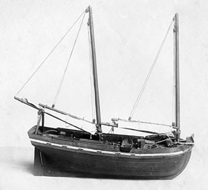
"Pinkys" were early nineteenth-century schooner-rigged derivations of Chebacco boats. This model is a good example of a traditional “sailor’s model,” or in this case, a sailmaker’s model, Mr. Nickerson having been a sailmaker.
Also filed under: Ship Models »


1860 In John J. Babson, History of the Town Gloucester (Gloucester, MA: Procter Brothers, 1860) Cape Ann Museum Library & Archives, Gloucester, Mass.
See p. 474.
View related catalogue entries (4) »
Also filed under: Babson History of the Town of Gloucester » // Fort (The) and Fort Point » // Gloucester Harbor, Inner / Harbor Cove » // Gloucester, Mass. - "Ten Pound Island Light » // Schooner (Coasting / Lumber / Topsail / Packet / Marsh Hay) » // Ten Pound Island »
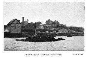
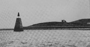
A "spindle" is a fixed marker to indicate a hazard to navigation (such as a rock which couldn't be seen at high tide). It serves the same purpose as a channel buoy, a "light beacon," or a “monument,” to warn vessels away from dangerous places or stretches of coastline. Spindles are usually iron rods with some sort of geometric object (round, flat, or triangular) on top, brightly painted (usually red) for visibility. Monuments, like the ones you see in Lane’s depictions of Half Way Rock or Norman’s Woe Reef, were made of stone and look like stumpy obelisks—or grave monuments. They were also essential as reference points for the early coastal surveys in their efforts to make more accurate charts.
In Castine, the notable square monument in the center of the harbor marked Hosmer's Ledge.
Photograph in The Illustrated Coast Pilot with Sailing Directions. The Coast of New England from New York to Eastport, Maine including Bays and Harbors, published by N. L. Stebbins, Boston
Also filed under: Gloucester Harbor, Inner / Harbor Cove »

Pencil and ink on paper
15 x 22 1/8 in.
Cape Ann Museum, Gloucester, Mass., Gift of Mr. Donald K. Usher, in memory of Mrs. Margaret Campbell Usher, 1984 (2401.19)
Also filed under: Gloucester Harbor, Outer » // Mackerel Fishing »
Stereograph card Castine Historical Society Collections (1996.1)
View related catalogue entries (2) »
Also filed under: Castine » // Historic Photographs »
According to the drawing Norman's Woe, 1861 (inv. 114) Lane made a painting for Florence Foster, most likely The Western Shore with Norman's Woe, 1862 (inv. 18). Foster was a long-time school teacher in Gloucester, having been born there in 1839, a daughter of Captain Thomas Jefferson Foster and Elizabeth Elwell Foster. Her great-grandfather was Colonel Joseph Foster, one of Gloucester's legendary Revolutionary War heroes.
Miss Foster's interest in culture, her ties to Gloucester and its rich history, and her situation as a teacher, made her an obvious patron of Fitz Henry Lane. She was friends with Isabel Babson Lane, who gave The Western Shore with Norman's Woe, 1862 (inv. 18) to the Cape Ann Historical Society, and the reason it is thought to be the one originally made for Foster. Foster's sister was married to Joseph Hooper, who accompanied Lane to Maine on his visits there, and her cousin was Caroline Stevens.
Florence was among the group of young, middle class New Englanders who came of age in the mid-nineteenth century, just as educational and employment opportunities for women were opening up. After completing her primary education in Gloucester, she attended Oread Institute, a women's college in Worcester, Massachusetts, and in 1860, at the age of twenty one, began working in the Gloucester schools. By 1866, she was principal of the girls' high school. Florence's obituary noted she was "a woman of ripe culture and pleasant manners, her well stored mind making her an entertaining companion, and her kindly nature making her friendship a valued treasure."
She died in 1892 without heirs.