An online project under the direction of the CAPE ANN MUSEUM
Meetinghouse Green
View related Fitz Henry Lane catalog entries (3) »
Gloucester’s First Parish was started here in 1641 when Pastor Blynman and his dissident group left the Plymouth Colony to start anew on Cape Ann. They were focused on agriculture, not fishing, and chose this relatively flat area of Cape Ann for its soil, fresh water, and relative protection from the sea weather to start their colony and build their first church. It was another fifty years before fishing began in earnest and the population gradually moved to the harbor area. This left Meetinghouse Green as a quiet pocket of small farms and tidal mills seemingly worlds away from the bustling harbor.
The Green, as it was commonly called, was located between the Annisquam River at Done Fudging and the head of the tidal Mill River to the north. The first meetinghouse on Cape Ann was built there in the 1640s, replaced by a successor built in 1752 which lasted until the 1840s when it was taken down for lack of funds and parishioners. The southern side of the Green is now almost completely obliterated by the Grant Circle rotary just over the Route 128 bridge as it comes onto Cape Ann. The northern side of the Green was up Washington St. from the rotary and occupied the present site of Addison Gilbert Hospital and the neighborhoods around it. The only structure left from the days when The Green was the town center is the Ellery House, which is now on the east side of Washington Street. This house is now owned by the Cape Ann Museum.
In Lane’s day there was a public landing on the Annisquam River at Done Fudging where the rotary now sits. Washington Street came north from the harbor and followed its present day route up the hill between the Babson house and Ellery house (moved to the east side of the street in 1953) and onto the Green. It was a quiet rural area in Lane’s time in contrast to the intense activity and swelling population of the harbor town.
Lane painted a number of pictures of this area, starting in the late 1840s with several self portraits of him painting in the landscape looking west from Done Fudging up the Annisquam River. Nowhere is the serene nature of this area better expressed than in two of Lane’s late views, Babson and Ellery Houses, Gloucester, 1863 (inv. 10) and The Babson Meadows at Riverdale, 1863 (inv. 11). The former shows the town landing at Done Fudging with a pole barge full of salt hay and the two prominent old houses flanking Washington Street. The view in Riverdale is taken from the north edge of The Green and looks up Mill River towards Riverdale in the distance.
Related tables: Old First Parish / Subsequent Fourth Parish Church (at the Green) » // Riverdale / Town Parish »
Cape Ann Museum Library & Archive
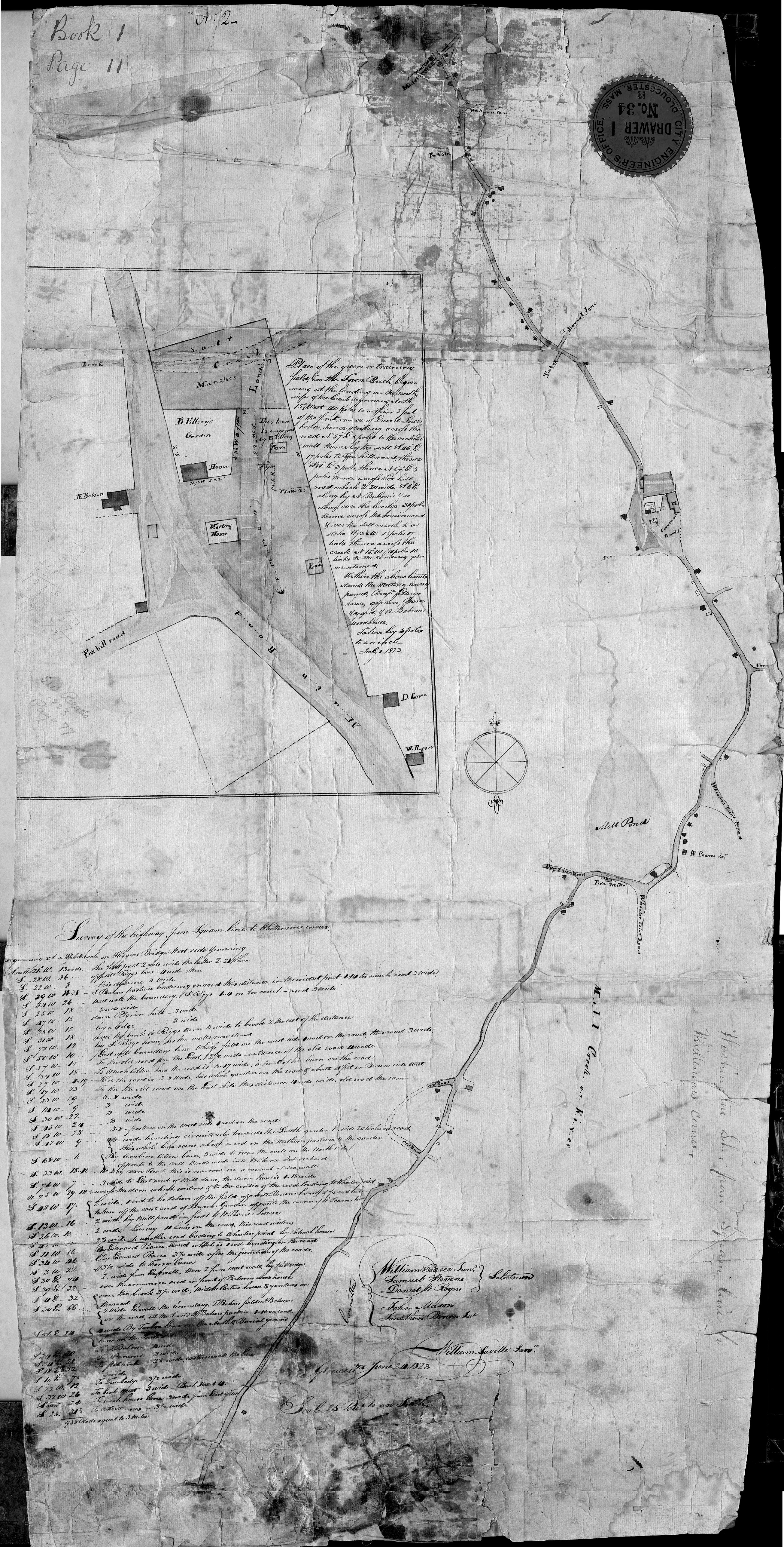
Grayscale version of color original
Map of Riverdale from the Mills to the Whittemore House at Middle and Washington Streeets ordered by a committee of selectmen, William Pearce, Samuel Stevens, Daniel H. Rogers with John Mason and Anthony Presson. Map drawn by surveyor William Saville and present to the committee in June, 1823. It contains a enlarged view of The Green, including the Ellery and Babson houses painted by Lane.
Also filed under: Babson House » // Low (David) House » // Maps » // Riverdale / Town Parish » // Riverdale Mills »
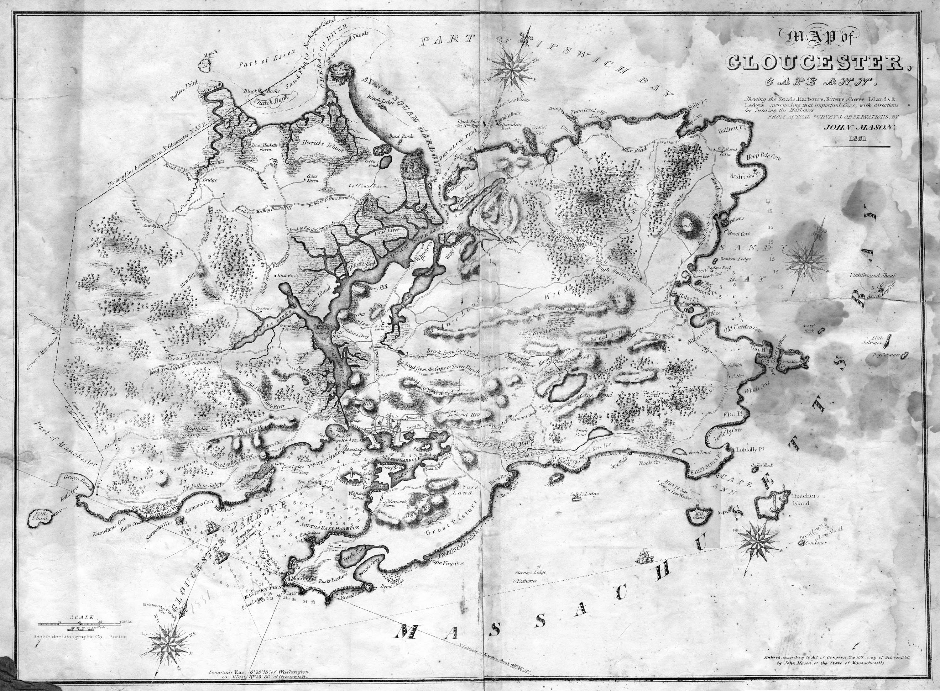
Lithograph
28.5 x 21 in.
Cape Ann Museum Library & Archive
When Massachusetts decreed that each town be mapped, John Mason drew the map of Cape Ann in 1830. This drawing was sent to the Senefelder Lithographic Company of Boston (owned by William Pendleton) to be printed, and then sold in Gloucester by W.E.P. Rogers, whose Gloucester Telegraph of February 12, 1831 announced, "A few specimen copies of the map, uncolored, have reached the town" and that they cost $1.25. Perhaps this business arrangement between Pendleton and Rogers provided Lane with his introduction to Pendleton.
Also filed under: Folly Cove » // Good Harbor Beach / Bass Rocks » // Maps » // Mason, John » // Pendleton's, Lith. – Boston » // Salt Island » // Thacher Island »