An online project under the direction of the CAPE ANN MUSEUM
Historical Materials: Flags, Lighthouses, & Navigation Aids
Historical Materials » Flags, Lighthouses, & Navigation Aids » Signal Systems (Flags & Maritime Codes)
You have navigated to this pages from catalog entry: Brig "Antelope" in Boston Harbor, 1863 (inv. 43)
Signal Systems (Flags & Maritime Codes)
View related Fitz Henry Lane catalog entries (31) »
The use of signal flags, for ship-to-ship communication, generally preceded land-based chains of maritime semaphore stations, the latter using flags or rotating arms, until the advent of the electric or magnetic telegraph.
Until the end of the Napoleonic wars, merchant ships generally sailed in convoy as ordered by the escorting warship(s) using a few simple flags. Peace brought independent voyaging, the end of the convoy system, and the realization by various authorities that merchant vessels now needed their own separate means of signaling to each other. This resulted in a handful of rival codes, each with its individual flags and syntax. In general, they each had a section enabling ship identification and also a "vocabulary" section for transmitting selected messages. It was not until 1857 that a common Commercial Code became available for international use, only gradually replacing the earlier ones. All existed side by side for a decade or two.
Signal systems for American ships were originally intended to identify a vessel by name and owner; only later were more advanced systems developed to convey messages. Most basic were private signals, or "house flags", each of a different design or pattern, identifying the vessel's owner; identification charts were local and poorly distributed, limiting their usefulness. A secondary signal, a flag or large pennant bearing the vessel's name, was sometimes flown by larger ships, but pictorial records of them are uncommon. These private signal flags usually flew from the foremasthead or main masthead if a three master ship. Pilot boats had their own identifying flags, blue and white as seen in Spitfire Entering Boston Harbor (inv. 536). Small vessels, such as schooners, often had a "tell-tale" pennant, an often-unmarked and often red flag, that was used to determine wind direction.
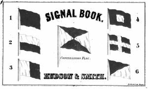
A numerical code flag system, identifying vessels by the code numbers, was introduced by Captain Frederick Marryat R.N. in 1817 for English vessels. American vessels soon adopted this system. Elford's "marine telegraphic system" was the first American equivalent to the Marryat code flags, first issued in 1823, and with changes, remaining in use until the late 1850s. Most of the signal flags on vessels depicted by Lane use Elford's; Brig "Antelope" in Boston Harbor, 1863 (inv. 43) is a noteworthy example of his depiction of Marryat's. The Elford's Code was popular in America on account of its simplicity and only required six blue and white flags. Eventually these changed to red and white, although it is unclear exactly when this happened. Instructions and a key ot the Elford's Code's use are included in successive editions of the Boston Harbor Signal Book.
Whereas the other codes employ at least ten flags of diverse shapes and colours, there are only six Elford flags in total, representing the numbers one to six. All are uniformly rectangular and monochrome in colour (either blue and white or red and white—or even black and white as in an early photograph). Selected from these six flags each individual vessel is allotted a combination of four flags to be prominently displayed as a vertical hoist. Reading from above down these convey its "designated number." Armed with this number and the type of vessel (e.g. ship, bark, brig, schooner /or steamer) the subject can be uniquely identified by reference to a copy of the Boston Harbor Signal Book for the appropriate year.
– A. Sam Davidson
As reproduced in Yankee Sailing Ship Cards by Allan Forbes and Ralph M. Eastman (Boston: State Street Trust Company, 1948).
Also filed under: "Eastern Star" (Bark) » // Forbes, Robert Bennet »
Harvard Depository: Widener (NAV 578.57)
For digitized version, click here.
Also filed under: Boston Harbor »
Boston: Eastburn's Press
New York Public Library
Complete book is included in Google Books, click here.


