An online project under the direction of the CAPE ANN MUSEUM
Historical Materials: Cape Ann Locales
Historical Materials » Cape Ann Locales » Cut, The (Stacy Blvd.)
You have navigated to this pages from catalog entry: Early Morning, Pavilion Beach, Gloucester, c.1850–55 (inv. 78)
Cut, The (Stacy Blvd.)
View related Fitz Henry Lane catalog entries (5) »
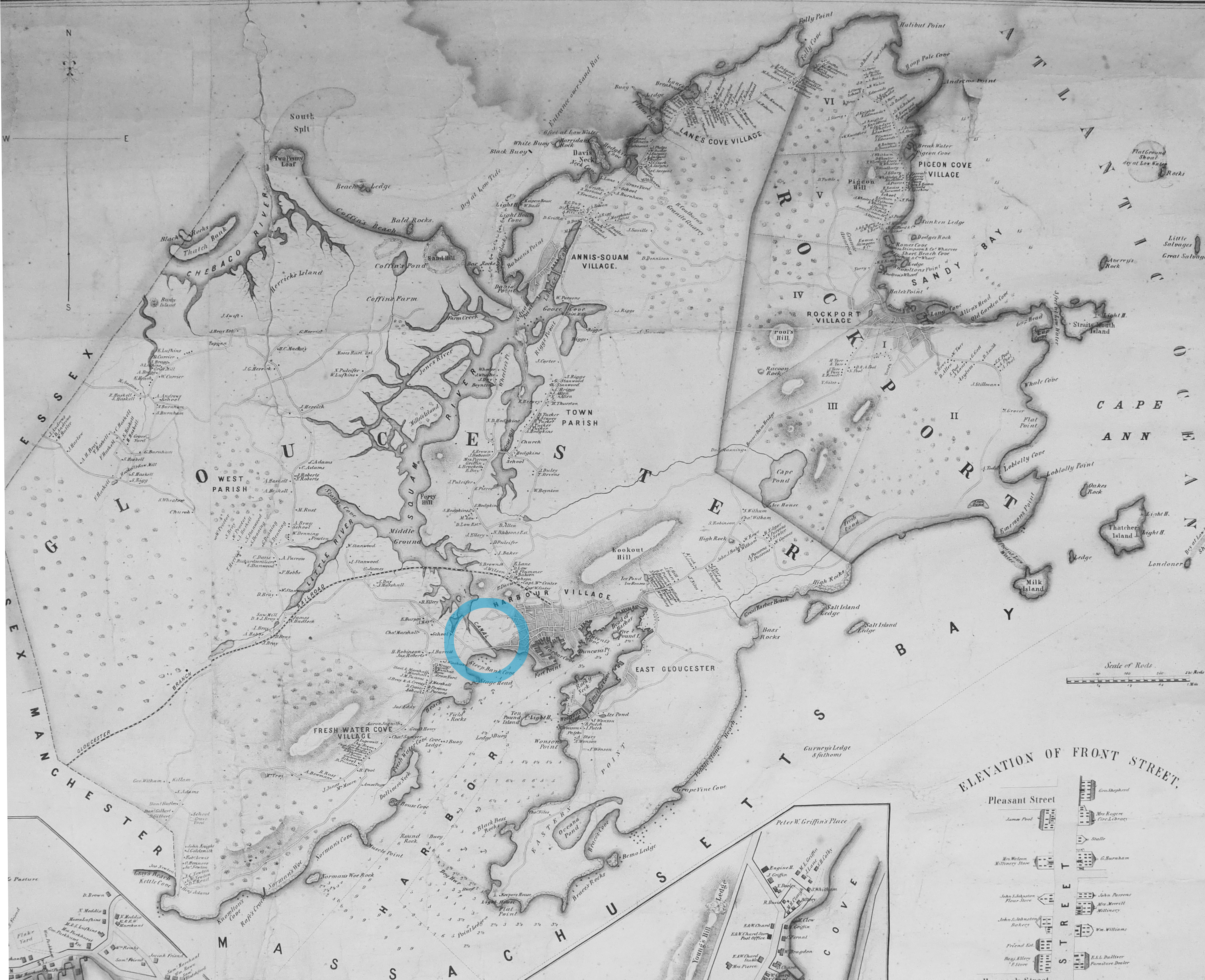
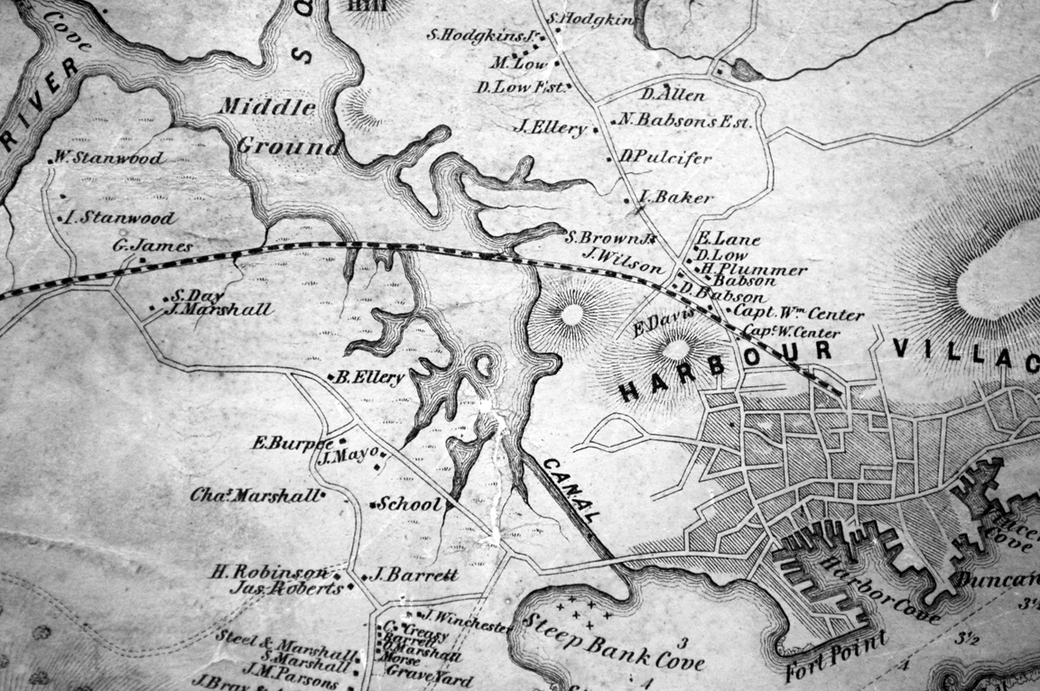
The Cut is the local name given to the canal that connects the outer Gloucester harbor to the navigable Annisquam River and thence on to the waters north of Cape Ann, so that vessels can in safety avoid circling the entire exposed eastern shoreline. It provided a vantage point for Lane's drawing Gloucester Beach from the Cut, 1850s (inv. 103) It was dug through the strip of beach separating the two bodies of water, first in the 1640s by the Reverend Richard Blynman, and is officially the Blynman Canal. This is purportedly the first canal dug in North America. For much of its history, however, the Cut has been filled in and the beach in its original state with a road laid over it, instead of cut through with a bridge over the canal (until 1950 and Route 128, the only vehicular access from the mainland to the Gloucester and Rockport peninsula). For a brief time around 1704 the canal was filled in by a storm but was soon dredged and re-opened. Then in 1723 it was again filled in by storms and did not get dug out until after 1822.
At this time, a consortium of Gloucester's leading men, most of them connected then and later with Lane, formed the company "Proprietors of the Gloucester Canal." They included Benjamin K. Hough, Jr.; James Mansfield; William Pearce, Jr.; John Mason; William Saville; Samuel Gilbert; and Winthrop Sargent. They managed to get the canal re-dug and a bridge in place, but the opening was too narrow to allow vessels of useful size to pass through. The bridge was also deemed unsafe. The company lost money and by 1843, the Cut was being refilled by the Town. During all the rest of Lane's life, the Cut as a canal did not exist. One could travel on a road, over sand, from the Pavilion, past the Ropewalk and the houses along the shore, to the western shores of the Harbor, Brookbank, Fresh Water Cove, and many other scenes and sites from which Lane painted. However, Lane and others continued to designate that section of their town as "The Cut."
After Lane's death, the quarrying interests on Wolf Hill (near the eastern end of the A. Piatt Andrew Bridge) were sufficiently motivated to reopen the canal in 1867.
– Sarah Dunlap (December, 2014)
Related tables: Annisquam River » // Granite Quarrying / Shipping » // Hough, Benjamin Kent »
44 x 34 in.
Henry Francis Walling, Map of the Towns of Gloucester and Rockport, Essex Co. Massachusetts. Philadelphia, A. Kollner, 1851
Cape Ann Museum Library & Archive
"Map of the Towns of Gloucester and Rockport, Massachusetts. H.F. Walling, Civil Engineer. John Hanson, Publisher. 1851. Population of Gloucester in 1850 7,805. Population of Rockport in 1850 3,213."
Also filed under: Babson House » // Town / Public Landings » // White-Ellery House »
Newsprint
D14-7
Cape Ann Museum Library & Archive
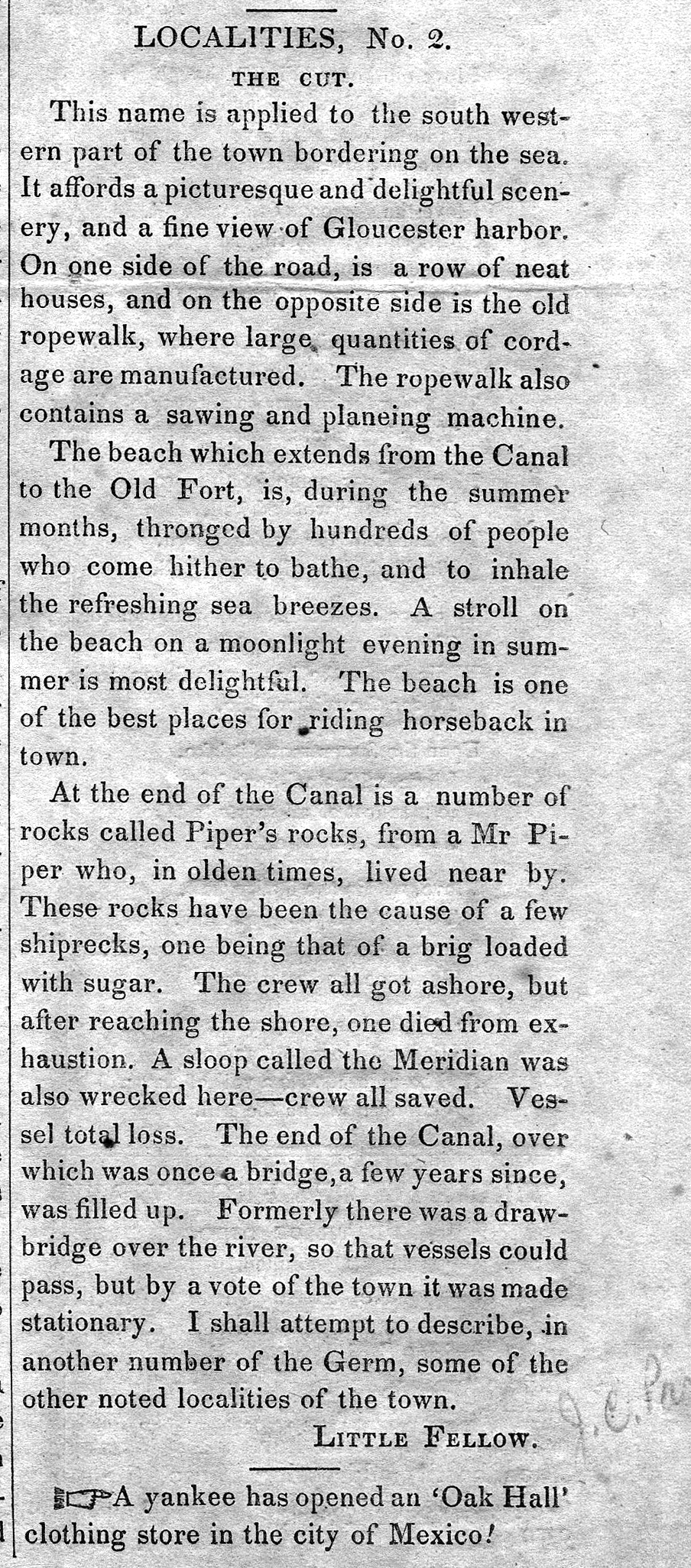
A short article entitled "The Cut," and signed "Little Fellow" describes the southwestern part of Gloucester and the beach between the Canal and the Old Fort.
Also filed under: Piper, John J. » // Ropewalk »
Personal journal
Wilson Museum, Castine, Maine
Box 2, F1 (A00772)
John Stevens was the younger brother of Joseph Stevens, and acquainted with Lane, spending time with him in Gloucester and at the family home in Castine. His journal, quoted below, includes reference to hunting plover and teal, school, sailing, local events. Mentions Castine mill, lighthouse, and block house.
"Friday [September] 17th: Cloudy all day. Wind N. blowing quite hard. A British Rig loaded with salt from Liverpool came into port last night. She run way up by the Monument and got aground. They kedged her off this P.M. and came down. She came in with one of these old English charts as her guide. They have the town set down on the Brooksville side, two miles + three quarters from the lighthouse."
"Wednesday [September] 22. . .Went down to the Indians Camp on the Back Cove. There were five camps of them."
Visits Gloucester from Castine:
"Wednesday [October] 27th. . .Left for Gloucester [from Boston] at 5 o'clock this P.M. arrived there safe + sound at 6 1/2 o'clock; went right down to the store and saw Joe. We then went up to his house and got supper.
"Thursday [October] 28th. At. Gloucester. Pleasant day. Went down to the "Cut" a gunning this morning before breakfast but saw no birds. Went out in the harbor this forenoon alone, had a fine sail but couldn't get a chance at any birds. Went out again this P.M. got down to East Point Light and the wind died all away, so I had to scull home."
"Friday 29th. Very pleasant day, went out in the harbor this morning with Joe. Took a walk this A.M. with "Lina", called on Mr. Lane + Doct. Hildreth. Joe + I went out in the harbor this P.M. I fired at some birds several times, but didn't get any. . . ."
Newsprint
Gloucester Telegraph
"The Reef of Norman's Woe ... is now commemorated in painting too, one of the finest pictures from Lane's easel. ... The sketch was made at the pretty spot commonly called, we believe, Master Moore's Cove. Being some little way off the main track to Rafe's Chasm, it is seldom visited, except by the more inquisitive lovers of nature who leave the beaten road to pry out such pleasant places. ... We wish it might find a home buyer, rather than go off to enrich another community." Flowery description follows, then "There is another and larger work in the artist's studio, which, happily, is to be retained. It received much well deserved notice and commendation. The subject is a view southward from the 'Cut,' with the picturesque promontory commonly known as 'Stage Fort,' and historically interesting as the supposed spot of the 'Landing at Cape Ann' in the middle distance, and Eastern Point on the extreme left." More description follows, "Among other attractions of the studio, and particularly worthy of mention, is a cabinet picture with an effect similar to the Norman's Woe. The subject is chosen from the many sketches of the grand scenery of the Maine sea-coast with which the artist's portfolio is rich. It is a view of the Camden mountains sketches from the Graves, a jagged ledge far out in the bay, which is accessible in only the smoothest water."
Also filed under: Camden Mountains » // Newspaper / Journal Articles » // The Graves »