An online project under the direction of the CAPE ANN MUSEUM
Catalogue Entry
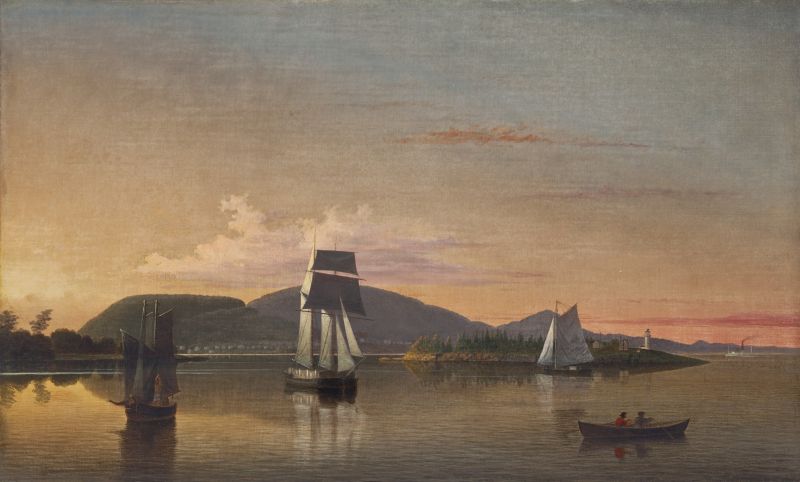
This painting is closely related to Camden Mountains from the South Entrance to the Harbor, 1859 (inv. 214) at the Farnsworth Museum in Rockland, Maine, as they appear to made been made from the same drawing Camden Mountains from the South Entrance to Harbor, 1855 (inv. 171) (below). The drawing was made during Lane's 1855 trip to Penobscot Bay with his friend Joseph Stevens, who later noted on it: "from the boat on our return to Rockland."
This Camden Mountains from the South Entrance to the Harbor (alternately titled Off Camden) is a slightly smaller version (18" x 30") of the Farnsworth painting of the same name (below) but is not a direct copy, as it shows subtle but important variations to the composition. It is not known which version was done first; an interesting puzzle is to compare the two, noting the differences and pondering which version might have "improved" upon the original in Lane's eyes.
Camden Mountains from the South Entrance to the Harbor, 1859 (inv. 214)
Both works have the same gold and brown tonality of the indirect sunset reflections on the water at the entrance to the harbor, and they are taken from the same vantage point. In this version, the sun has not quite set and is lighting up the sails of the lumber schooner and the corner of Negro Island (now Curtis Island). In comparison to the Farnsworth version, the sky is lighter, with more reds and yellows. The Farnsworth version is from a few minutes later; the sun has set and the light is indirect, with an overall duskier palette.
The vessels have been slightly re-arranged in the two versions. This version shows the two-masted boat in the left foreground (a yawl boat with a schooner rig) with its sails being raised or lowered. The right foreground shows a small double-ended boat (called a "pea pod" and then unique to Maine harbors) rowed by two men; the Farnsworth version is without the small boat, but a floating log is similarly placed at the same angle.
In front of the lighthouse island, there is a sloop heading to the left that is not in the Farnsworth version; that version has a distant lumber schooner in the shadow of the left-hand island that is not to be found in this version. The larger lumber schooner in the left center of this painting appears in the right center in the Farnsworth painting. The distant steamship, seen in the far right here, is found in the center of the Farnsworth painting.
The evolution of Lane's work over the years shows a consistent simplifying of composition and increasing emphasis on the space and light within a composition. Based on that premise, one could surmise that this painting was done first. It has more vessels leading the eye in multiple directions, while the Farnsworth painting has reduced the number of vessels and moved the main vessel to open up the left center. This leads the eye more directly into the shadows of the harbor entrance and the glowing light below the horizon.
This version of Camden Mountains from the South Entrance to Harbor is undated, but clearly from after 1855 (the date of the drawing). It is consistent with Lane's mature style of the late 1850s. Like many paintings of this period, it may show traces of Lane's student, Mary Mellen, or a possible later restoration in some areas of the main lumber schooner and sails. Overall, it is a beautiful example of Lane's late luminist style, balancing light, composition and space in a vision of serenity captured in a typical moment along the Maine coast.
– Sam Holdsworth
Historical Materials
The Camden Mountains, also called the Camden Hills, are located just northeast of the town of Camden. The range includes Mount Megunticook, upon whose shoulders Mount Battie sits, Cameron Mountain, and Bald Rock Mountain. They stand high above West Penobscot Bay between Camden and Lincolnville, looking east toward Mount Desert and the rising sun. The Wabenaki, loosely defined as the "people of the dawn," greeted their maritime world, "the dawn land," from the Camden Hills, and other high points, including Mount Wallamatogus in Penobscot (460 feet), Awan-adjo (at Bluehill), Caterpillar Hill in Sedgwick (with its panoramic sweep which stretches from the Camden Hills to Mount Desert and far out into Penobscot Bay), and atop Cadillac Mountain, Mount Desert. It is from the same peaks that artists and pilgrims alike still climb to view Penobscot Bay.
Mad-kam-ig-os'-sek, "big high land," is the Wabenaki word for Camden, and Meg-un-ti-cook, "big mountain harbor," the name for the harbor, is now used for Mount Megunticook. The inner harbor, quiet and safe, would have been the ideal place for a large, oceangoing canoe to lay up when the sea was rough. Capt. John Smith visited this place in 1614, during the Beaver Wars, and noted that the high mountains were used as a refuge from the Mik'maq of the Maritimes who fought the Wabenaki of Penobscot Bay to maintain their place as middlemen in the fur trade. These raiders would travel along the Downeast coast in their shallops. Mount Battie, of many spellings, was noted as Mount Betty in documents dating from 1757. It is a European corruption of a word borrowed from another place, the Madambettox Hills of Rockland.
-Mark Honey
References:
Eckstorm, Fannie Hardy, "Indian Place-Names of the Penobscot Valley and the Maine Coast," University of Maine Studies, 2nd Series, #55, November 1941, reprinted 1960 by the University of Maine Press. DeLorme's Atlas. Frank G Speck's "Penobscot Man," University Of Pennsylvania Press, 1940.
Newsprint
Gloucester Telegraph
"The Reef of Norman's Woe ... is now commemorated in painting too, one of the finest pictures from Lane's easel. ... The sketch was made at the pretty spot commonly called, we believe, Master Moore's Cove. Being some little way off the main track to Rafe's Chasm, it is seldom visited, except by the more inquisitive lovers of nature who leave the beaten road to pry out such pleasant places. ... We wish it might find a home buyer, rather than go off to enrich another community." Flowery description follows, then "There is another and larger work in the artist's studio, which, happily, is to be retained. It received much well deserved notice and commendation. The subject is a view southward from the 'Cut,' with the picturesque promontory commonly known as 'Stage Fort,' and historically interesting as the supposed spot of the 'Landing at Cape Ann' in the middle distance, and Eastern Point on the extreme left." More description follows, "Among other attractions of the studio, and particularly worthy of mention, is a cabinet picture with an effect similar to the Norman's Woe. The subject is chosen from the many sketches of the grand scenery of the Maine sea-coast with which the artist's portfolio is rich. It is a view of the Camden mountains sketches from the Graves, a jagged ledge far out in the bay, which is accessible in only the smoothest water."
Also filed under: Cut, The (Stacy Blvd.) » // Newspaper / Journal Articles » // The Graves »
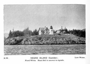
Curtis Island is located a short distance from Camden Harbor in Penobscot Bay. The island was known as Negro Island, from Revolutionary times to the 1930s, and in the early part of the nineteenth century as Mark Island. Abraham Ogier, in a deposition submitted in 1832, claimed that he had pastured hogs on the island and planted potatoes as early as 1773, and that he was driven off by the British in 1779. His grandson Lewis pastured sheep here for 40 years. The island was sold to the US government for a light station for $400 in 1835, and the Negro Island Light was established by an appropriation of $4500 in 1836. M.K.M. Bowers was the light keeper when Lane portrayed the island at dawn. The island was renamed Curtis Island in 1934 after Cyrus H.K. Curtis, publisher of the "Saturday Evening Post," a longtime summer resident and benefactor of Camden.
– Mark Honey
Reference:
McLane, Charles B, and McLane, Carol Evarts, "Islands of the Mid-Maine Coast," Penobscot Bay, Volume 1, Revised Edition, Tilbury House, Publishers, Gardiner, Maine, and the Island Institute, Rockland, Maine, page 124.
Photograph
From book "The Illustrated Coast Pilot with Sailing Directions. The Coast of New England from New York to Eastport, Maine including Bays and Harbors." Published by N.L. Stebbins, Boston, Mass. 1891
Also filed under: Camden, Maine – Negro (Curtis) Island Light »
Photograph
National Archives
Also filed under: Camden, Maine – Negro (Curtis) Island Light »
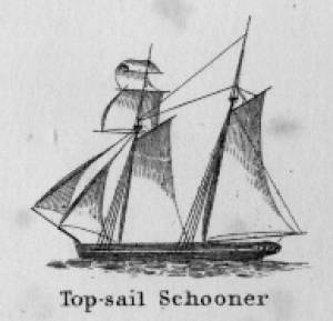
Schooners in Lane’s time were, with few exceptions, two-masted vessels carrying a fore-and-aft rig having one or two jibs, a fore staysail, gaff-rigged fore- and main sails, and often fore- and main topsails. One variant was the topsail schooner, which set a square topsail on the fore topmast. The hulls of both types were basically similar, their rigs having been chosen for sailing close to the wind. This was an advantage in the coastal trade, where entering confined ports required sailing into the wind and frequent tacking. The square topsail proved useful on longer coastwise voyages, the topsail providing a steadier motion in offshore swells, reducing wear and tear on canvas from the slatting of the fore-and-aft sails. (1)
Schooners of the types portrayed by Lane varied in size from 70 to 100 feet on deck. Their weight was never determined, and the term “tonnage” was a figure derived from a formula which assigned an approximation of hull volume for purposes of imposing duties (port taxes) on cargoes and other official levies. (2)
Crews of smaller schooners numbered three or four men. Larger schooners might carry four to six if a lengthy voyage was planned. The relative simplicity of the rig made sail handling much easier than on a square-rigged vessel. Schooner captains often owned shares in their vessels, but most schooners were majority-owned by land-based firms or by individuals who had the time and business connections to manage the tasks of acquiring and distributing the goods to be carried. (3)
Many schooners were informally “classified” by the nature of their work or the cargoes they carried, the terminology coined by their owners, agents, and crews—even sometimes by casual bystanders. In Lane’s lifetime, the following terms were commonly used for the schooner types he portrayed:
Coasting schooners: This is the most general term, applied to any merchant schooner carrying cargo from one coastal port to another along the United States coast (see Bar Island and Mt. Desert Mountains from Somes Settlement, 1850 (inv. 401), right foreground). (4)
Packet schooners: Like packet sloops, these vessels carried passengers and various higher-value goods to and from specific ports on regular schedules. They were generally better-maintained and finished than schooners carrying bulk cargoes (see The Old Fort and Ten Pound Island, Gloucester, 1850s (inv. 30), center; and Gloucester Inner Harbor, 1850 (inv. 240), stern view). (5)
Lumber schooners: Built for the most common specialized trade of Lane’s time, they were fitted with bow ports for loading lumber in their holds (see View of Southwest Harbor, Maine: Entrance to Somes Sound, 1852 (inv. 260)) and carried large deck loads as well (Stage Rocks and the Western Shore of Gloucester Outer Harbor, 1857 (inv. 8), right). Lumber schooners intended for long coastal trips were often rigged with square topsails on their fore masts (see Becalmed Off Halfway Rock, 1860 (inv. 344), left; ; and Lumber Schooner in a Gale, 1863 (inv. 552)). (6)
Schooners in other specialized trades. Some coasting schooners built for carrying varied cargoes would be used for, or converted to, special trades. This was true in the stone trade where stone schooners (like stone sloops) would be adapted for carrying stone from quarries to a coastal destination. A Lane depiction of a stone schooner is yet to be found. Marsh hay was a priority cargo for gundalows operating around salt marshes, and it is likely that some coasting schooners made a specialty of transporting this necessity for horses to urban ports which relied heavily on horses for transportation needs. Lane depicted at least two examples of hay schooners (see Gloucester Harbor, 1850s (inv. 391), left; and Coasting Schooner off Boon Island, c.1850 (inv. 564)), their decks neatly piled high with bales of hay, well secured with rope and tarpaulins.
– Erik Ronnberg
References:
1. Howard I. Chapelle, The History of American Sailing Ships (New York: W.W. Norton & Co., 1935), 258. While three-masted schooners were in use in Lane’s time, none have appeared in his surviving work; and Charles S. Morgan, “New England Coasting Schooners”, The American Neptune 23, no. 1 (DATE): 5–9, from an article which deals mostly with later and larger schooner types.
2. John Lyman, “Register Tonnage and its Measurement”, The American Neptune V, nos. 3–4 (DATE). American tonnage laws in force in Lane’s lifetime are discussed in no. 3, pp. 226–27 and no. 4, p. 322.
3. Ship Registers of the District of Gloucester, Massachusetts, 1789–1875 (Salem, MA: The Essex Institute, 1944). Vessels whose shipping or fishing voyages included visits to foreign ports were required to register with the Federal Customs agent at their home port. While the vessel’s trade or work was unrecorded, their owners and master were listed, in addition to registry dimensions and place where built. Records kept by the National Archives can be consulted for information on specific voyages and ports visited.
4. Howard I. Chapelle, The National Watercraft Collection (Washington, DC: Smithsonian Institution, 1960), 40, 42–43.
5. Ibid., 42–43, 73.
6. Ibid., 74–76.
In R. H. Dana, The Seaman's Friend, 13th ed. (Thomas Groom & Co. Publisher, 1873)
A topsail schooner has no tops at her foremast, and is fore-and-aft rigged at her mainmast. She differs from an hermaphrodite brig in that she is not properly square-rigged at her foremast, having no top, and carrying a fore-and-aft foresail instead of a square foresail and a spencer.

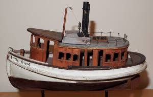
Detail views: marine railway and hauling cradle for vessel Wood rails, metal rollers, chain; wood cradle. Scale: ½" = 1' (1:24) Original diorama components made, 1892; replacements made, 1993. Cape Ann Museum, from Gloucester Chamber of Commerce, 1925 (2014.071)
A schooner is shown hauled out on a cradle which travels over racks of rollers on a wood and metal track.
Also filed under: Burnham Brothers Marine Railway » // Marine Railways »

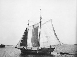
c. 1900 Glass plate negative Collection of Erik Ronnberg
Also filed under: Lobstering »
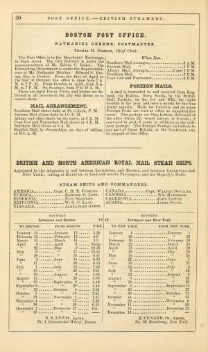
"The Maine Register for the Year 1855, embracing State and County Officers, and an abstract of the law and resolves; together with a complete business directory of the state, and a variety of useful information."
Details about Maine's lumber trade in 1855, see pp. 250–52
Also filed under: Castine » // Lumber Industry »

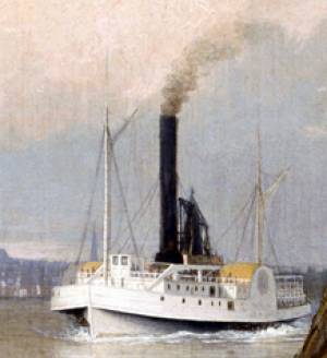
"Engine-powered vessel" is a collective term used by nautical historians to include all vessel types using engine power of any type for propulsion, whether assisted by sails, oars, or other motive power. In Lane's time, steam reciprocating engines fueled by wood or coal were the only practical source of this power for ships using paddle-wheels or screw propellers to convert heat energy into motion.
For most of the nineteenth century, steamships had sails for auxiliary power; indeed the earliest examples relied principally on sails, using engine power in calm weather to shorten the voyage time or keep to a schedule. As engines became more efficient, powerful, and reliable, sail plans were reduced, to be used only to steady a vessel's motion in a seaway (for the sake of seasick passengers), or to maintain headway if the engine broke down. Only harbor craft, ferry boats, and coastwise passenger steamers relied solely on engine power.
Among Lane's depictions of steamships, the auxiliary steam packet Auxiliary Steam Packet Ship Massachusetts, n.d. (inv. 442) is a good example of primary reliance on sails, while the steam demi-bark The "Britannia" Entering Boston Harbor, 1848 (inv. 49) and the Cunard Liner "Britannia", 1842 (inv. 259) have relegated sails to secondary (or simply emergency) motive power.
– Erik Ronnberg
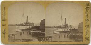
Stereograph card Castine Historical Society Collections (2015.03)
Also filed under: Historic Photographs » // Steamers »
Published by James French, Boston
Volume 1848-49
Boston Public Library
Call number 39999059856813
See p. 30 of directory.
Also filed under: "Britannia" (Cunard Steamship) » // "Caledonia" (Cunard Steamship) » // Trade Routes and Statistics »
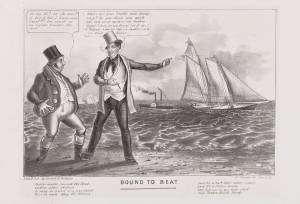
Cartoon
9 1/4 x 13 3/4 in (23.495 x 34.925 cm)
Peabody Essex Museum, Salem, Mass.
Jonny and a Yankee:
Jonny: "Ho my Hi! 'ow she goes!! it his'nt fair I ham sure t'aint!!! She must 'av an engine hunder the keel..."
Yankee: "Where are your yachts now, Jonny? s-a-y- Do you think your wash tubs can come up to a real Yankee Clipper? Sorry for you, Jonny, but it can't be helped... A Yankee Ship a Yankee Crew, you know Jonny."
Also filed under: "America" (Schooner Yacht) »
Lithograph
Library of Congress Catalog Number 2002706878
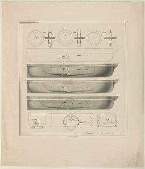
Design of side wheel steamer showing wheel mechanism, side view and cross-section in ten figures. This design proved a failure in the few vessels that employed it. The paddle wheel enclosures filled with water, causing resistance which greatly impaired efficiency and increased fuel consumption.
– Erik Ronnberg
Oil on canvas
Maine Maritime Museum
Also filed under: Castine »
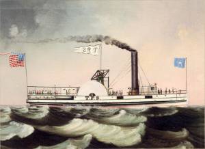
Steamer schedules for 1855, including the schedule for the steamer, "T. F. Secor" which served Castine, see pp. 234–35.
Also filed under: "T. F. Secor" (Steamboat) » // Castine » // Publications » // Steamers »
The Curtis Island Light is located on the seven-acre Curtis Island, a short distance off the coastline of Camden, Maine in the Penobscot Bay. The island was formerly known as Negro Island because the African-American cook of early settler, James Richards, admired the island greatly, but was later named Curtis Island in memory of Camden summertime resident, Cyrus H. K. Curtis. The original lighthouse was built in 1835 by contractor George Gault. Fifteen years later, an inspection report from 1850 stated that the lighthouse needed "immediate attention" and in 1855 the lighthouse was given a wooden outer sheath and new shingling in an attempt to stop the leaks. Lane painted the Curtis Island Light on at least two separate occasions, in 1852 and 1855, during his trips to the Maine coast.
This is information has been shared with the Lane project by Jeremy D'Entremont. More information can be found on his website, www.newenglandlighthouses.net and in his book The Lighthouse Handbook of New England.
Photograph
From book "The Illustrated Coast Pilot with Sailing Directions. The Coast of New England from New York to Eastport, Maine including Bays and Harbors." Published by N.L. Stebbins, Boston, Mass. 1891
Also filed under: Negro (Curtis) Island, Camden Harbor »
Photograph
National Archives
Also filed under: Negro (Curtis) Island, Camden Harbor »
The timber trade played an important role in New England’s economy from Colonial days through the mid-19th century, supplying the vast quantities of lumber which a rapidly growing nation demanded. While Cape Ann’s woodlands were depleted early on, timber continued to be harvested from northern New England and the Maritime Provinces right up to the Civil War.
With a deep and safe harbor, Gloucester often served as a layover spot where vessels bound from Maine to Boston, New York or Baltimore and heavily laden with lumber could ride out bad weather. Because of this, Fitz Henry Lane’s paintings of Gloucester Harbor often show a schooner or a brig, loads of lumber clearly visible on their decks, sheltering along the Western Shore.
References:
Honey, Mark E., "King Pine, Queen Spruce, Jack Tar," An Intimate History of Lumbering on the Union River, Volumes 1-5. This source, in its entirety, lays down the foundation of Downeast Maine's unique culture which was built upon pine lumber and timber, the cod fisheries, coasting, shipbuilding, and the interrelationships of family and community.

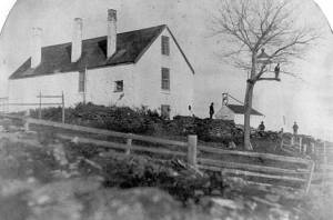
1852 Photograph
Also filed under: Schooner (Coasting / Lumber / Topsail / Packet / Marsh Hay) »
Advertisement for The Bangor News Company, est. January 31, 1881 Castine Historical Society Collections (2008.02)
Also filed under: Historic Photographs »
"The Maine Register for the Year 1855, embracing State and County Officers, and an abstract of the law and resolves; together with a complete business directory of the state, and a variety of useful information."
Details about Maine's lumber trade in 1855, see pp. 250–52
Also filed under: Castine » // Schooner (Coasting / Lumber / Topsail / Packet / Marsh Hay) »
Marks: on stretcher, "Off Camden" (not visible)