loading 
Fitz Henry Lane
HISTORICAL ARCHIVE • CATALOGUE RAISONNÉ • EDUCATIONAL RESOURCE
An online project under the direction of the CAPE ANN MUSEUM
An online project under the direction of the CAPE ANN MUSEUM
Catalog entry
inv. 143
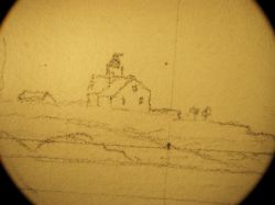
View in Gloucester Harbor
1850s Graphite on paper (3 sheets) 9 1/2 x 34 3/4 in. (24.1 x 88.3 cm) Inscribed and signed lower center (in pencil): View in Gloucester Harbor / F.H. Lane del.
|
Related Work in the Catalog
Supplementary Images
Provenance (Information known to date; research ongoing.)
the Artist, Gloucester, Mass.
Joseph L. Stevens, Jr., Gloucester, Mass.
Samuel H. Mansfield, Gloucester, Mass.
Cape Ann Museum, Gloucester, Mass., 1927
Marks & Labels
Marks: Inscribed upper left (in red ink): 67 [numbering system used by curator A. M. Brooks upon Samuel H. Mansfield's donation of the drawings to the Cape Ann Museum]
Exhibition History
Cape Ann Historical Association, Gloucester, Massachusetts, Training the Eye and Hand: Fitz Hugh Lane and Nineteenth Century American Drawing Books, September 17, 1993–January 29, 1994.
Published References
Paintings and Drawings by Fitz Hugh Lane. Gloucester, MA: Cape Ann Historical Association, 1974., fig. 77.
Training the Eye and the Hand: Fitz Hugh Lane and 19th Century Drawing Books. Gloucester, MA: Cape Ann Historical Association, 1993., p. 24, fig. 23, View in Gloucester Harbor.
Davis, Elliot Bostwick. "American Drawing Books and Their Impact on Fitz Hugh Lane." Proceedings of the American Antiquarian Society 105, part 1 (1995)., fig. 7, p. 95, text, p. 93. ⇒ includes  text
text
Ronnberg, Erik A.R., Jr. "Views of Fort Point: Fitz Hugh Lane's Images of a Gloucester Landmark." Cape Ann Historical Association Newsletter 26, no. 2–4 (April, July, September 2004)., fig. 7. ⇒ includes  text
text
Craig, James. Fitz H. Lane: An Artist's Voyage through Nineteenth-Century America. Charleston, SC: The History Press, 2006., fig. 6, text, p. 94.
Barnhill, Trafton. Drawn from Nature & on Stone: the Lithographs of Fitz Henry Lane. Gloucester, MA: Cape Ann Museum, 2017., fig. 26, View in Gloucester Harbor. ⇒ includes  text
text


Commentary
From the perspective of Duncan's Neck, this drawing shows Gloucester's Inner Harbor. Ten Pound Island and the lighthouse are to the left, while George Rogers's large commercial building, his rapidly expanding wharf, and the windmill, which had recently been moved here from its original location near Pavilion Beach, are just to the right of the center of the composition. The architectural element behind Rogers's building is most likely the Fort.
Lane used three pieces of paper to compose this drawing, which served as a sketch for Gloucester Inner Harbor, 1850 (inv. 240). The notable difference between the two pictures is the absence of vessels in the drawing. This is typical of Lane's drawings—he often recorded only the landscape features in his pencil drawings or in the underdrawings of paintings, adding the vessels in the final stages. That he intended to add the fleet of fishing schooners present in the painting is indicated, however, by the diagonal perspective lines in this drawing, which would help him to represent the vessels in the proper proportions.
This drawing is also useful in the way in which it shows the development of George H. Rogers's wharf. Rogers was a merchant and owner of a great deal of the waterfront. He was known for the huge wharf he constructed in the Inner Harbor. In this drawing it is under construction—a derrick used to drive wharf pilings can be seen behind the left side of the wharf. Erik Ronnberg has documented the growth of the harbor and Rogers's wharves in an essay for the Cape Ann Museum.
The three sheets of paper are glued together to make a drawing surface 9 1/2” high by 34 3/4” wide. The drawing's width is almost exactly the same as the bottom of the painting, which measures 36". A horizon line was drawn over the assembled sheet’s whole width (it can be seen over its whole length under magnification). Pin pricks were made every 4 1/16” on this line—seven in all, dividing the sheet into eight equal segments. The care taken in this process raises questions over what kind of viewing device Lane was using to warrant this effort and that permitted such remarkable accuracy in his placement of landmarks and buildings. To date, nothing has been found regarding Lane’s training or use of viewing instruments for this purpose, which should prompt examination of the kinds of tools and methods then available.
If Lane’s accuracy of proportion and detail in man-made structures is impressive, it is no less so in his renderings of the natural surroundings. The rock formations along the foreground shoreline are carried over stone-for-stone to the painting, implying his intent on rendering the whole scene exactly as he saw it. Without all the vessels included in the painting, it is possible to look out to the entrance to Gloucester Harbor and see many coastal features lining both sides.
A Visual Guide to the Painting
– Erik Ronnberg