loading 
Fitz Henry Lane
HISTORICAL ARCHIVE • CATALOGUE RAISONNÉ • EDUCATIONAL RESOURCE
An online project under the direction of the CAPE ANN MUSEUM
An online project under the direction of the CAPE ANN MUSEUM
Catalog entry
inv. 125
Gloucester from Steepbank
c. 1855 Graphite on paper 10 1/4 x 16 in. (26 x 40.6 cm) Inscribed lower center (in pencil): Gloucester from Steepbank / F.H. Lane del. / Remainder of sketch at other end of the sheet
|
Verso
Related Work in the Catalog
Supplementary Images
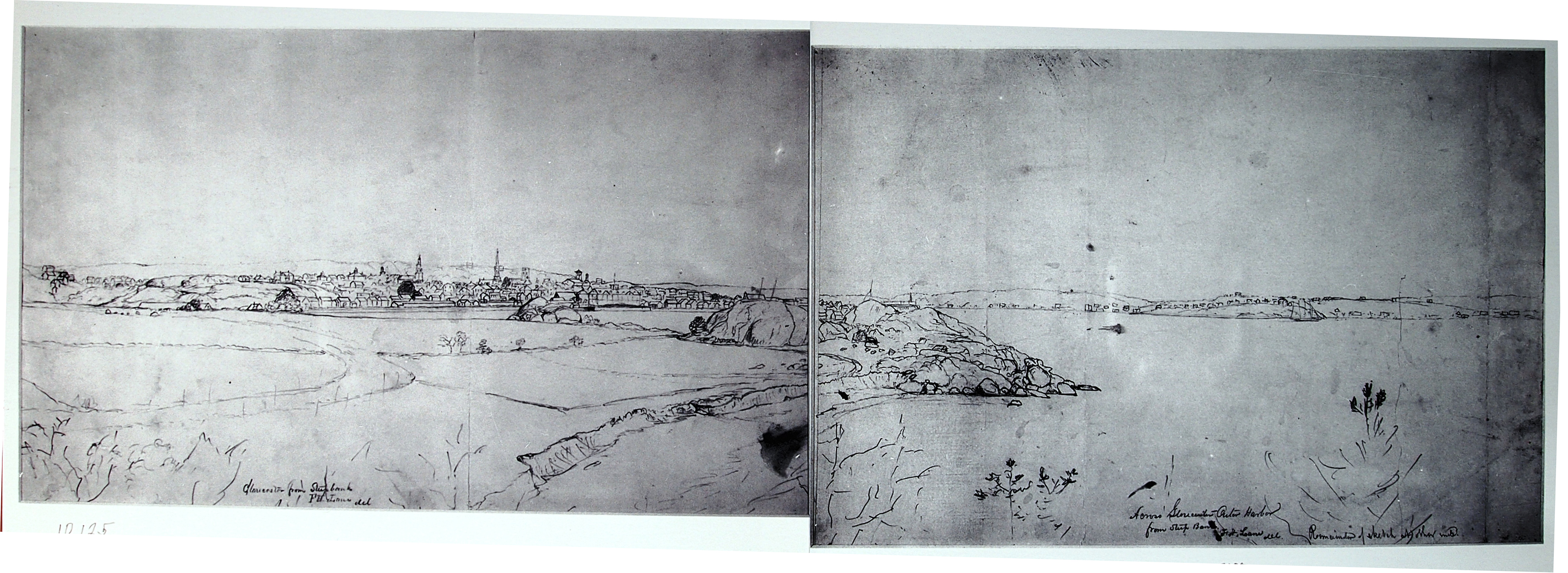
Image combining inv.125 with inv.234
Provenance (Information known to date; research ongoing.)
the Artist, Gloucester, Mass.
Cape Ann Museum, Gloucester, Mass.
Marks & Labels
Marks: Inscribed upper left (in red ink): 75 [numbering system used by curator A. M. Brooks upon Samuel H. Mansfield's donation of the drawings to the Cape Ann Museum]
Exhibition History
Cape Ann Historical Association, Gloucester, Massachusetts, Training the Eye and Hand: Fitz Hugh Lane and Nineteenth Century American Drawing Books, September 17, 1993–January 29, 1994.
Published References
Paintings and Drawings by Fitz Hugh Lane. Gloucester, MA: Cape Ann Historical Association, 1974., fig. 43.
Training the Eye and the Hand: Fitz Hugh Lane and 19th Century Drawing Books. Gloucester, MA: Cape Ann Historical Association, 1993., p. 16, fig. 9, Gloucester from Steepbank.
Commentary
This pencil drawing is the left half of a view of Gloucester Harbor from Western Avenue. Looking out over Fishermen's Field (now Stage Fort Park), Gloucester's downtown district and prominent buildings are seen in the distance. The drawing continues on another sheet—Across Gloucester Outer Harbor from Steepbank (inv. 234)—which shows the rocky southeast point of Fishermen's Field and Gloucester's Outer Harbor.
The drawing has long been undated, however a newspaper article from April 1854 (below) discusses the construction of the second steeple from the left, that of the Trinity Congregational Church. Therefore the drawing can confidently be dated to 1855 or later.
The land rising to the west of Fisherman's Field was then called Steepbank, on which a house by the same name was located. While there has speculation that Lane made this drawing from that house, its elevation was too high, as can be seen in a stereograph made from that building. The most likely viewpoint is Western Avenue, directly below the house, looking northeast, as shown on the viewpoint map.
When joined to its right half Across Gloucester Outer Harbor from Steepbank (inv. 234) the whole drawing measures 30 ¾” wide by 10 ¾” high, including mismatches of the adjoining edges due to subsequent trimming of top and bottom edges. No painting based on this drawing in its original state, or its separate halves, has so far been found.
This, the left half, has no verso image, but the right half was glued to a sheet of similar dimensions and is now the verso side of the drawing Gloucester Outer Harbor, from the Cut, 1850s (inv. 109).
At the time Lane made this drawing, Fishermen’s Field was owned by Benjamin Kent Hough, who also owned the Sargent House on Middle Street and the rope walk on the waterfront side of Canal Street (now Western Avenue) between the Cut and the Pavilion Hotel. The latter’s long buildings are easily visible in this drawing.
The rock formation called Stage Head (see viewpoint map) was fortified during four wars: the first, the American Revolution; the second, the War of 1812; the third, the Civil War; and the fourth, the Spanish-American War. After its acquisition by the City of Gloucester in 1897, Fishermen’s Field was opened to the public and re-named Stage Fort park. The beach at right, now known as Cressy’s Beach, was called Field Beach or Long Beach in Lane’s time.
—Erik Ronnberg
References:
1. Joseph E. Garland, “The Gloucester Guide” (Rockport, MA: Protean Press, 1990), pp. 1 – 3.
2. Mary Ray and Sarah Dunlap, “Gloucester, Massachusetts Historical Time Line, 1000-1999” (Gloucester, MA: The Pressroom, 2002), References to Fishermen’s Field, Stage Fort Park, Benjamin Kent Hough, Canal Street, and rope walks.
Key to identified buildings:
1. Residence of C.F. Hovey
2. Union School, later site of Collins School House
3. First Universalist Church
4. Congregational Church
5.Unitarian Church
6. Baptist Church
7. Methodist Church
8. Pavilion Hotel
9. Second Universalist Church
Viewpoint map showing Lane's assumed location when making this drawing